Liege Island
From Wikishire
| Liege island | |
| Location | |
| Location: | 64°1’10"S, 61°55’60"W |
| Data | |
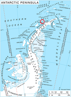
Liege Island is an island, 9 nautical miles long and 3 nautical miles wide, in the Palmer Archipelago, off Graham Land in the British Antarctic Territory. It lies immediately northeast of Brabant Island and is separated from Hoseason Island and Christiania Islands to the northeast by Croker Passage. Its interior is occupied by Brugmann Mountains.
The island was charted by the Belgian Antarctic Expedition (1897–1899) under Adrien de Gerlache, who named it for the Province of Liège in Belgium.[1]
Maps
- British Antarctic Territory. Scale 1:200000 topographic map. DOS 610 Series, Sheet W 64 60. Directorate of Overseas Surveys, UK, 1978.
- British Antarctic Territory. Scale 1:200000 topographic map. DOS 610 Series, Sheet W 64 62. Directorate of Overseas Surveys, UK, 1980.
- Antarctic Digital Database (ADD). Scale 1:250000 topographic map of Antarctica. Scientific Committee on Antarctic Research (SCAR), 1993-2012.
Outside links
References
- ↑ Liège Island. SCAR Composite Antarctic Gazetteer.
