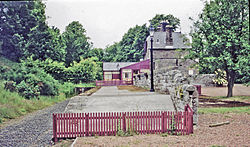
Ilderton, Northumberland
| Ilderton | |
| Northumberland | |
|---|---|
 The former Ilderton railway station | |
| Location | |
| Grid reference: | NU015215 |
| Location: | 55°29’14"N, 1°58’40"W |
| Data | |
| Population: | 235 (2011) |
| Postcode: | NE66 |
| Local Government | |
| Council: | Berwick-upon-Tweed |
| Parliamentary constituency: |
Berwick-upon-Tweed |
Ilderton is a small village in Northumberland, at the on the edge of the Northumberland National Park, between Lilburn in the east and Harehope Hill in the west.[1]
The village is named after the Ilderton family of Ilderton Hall, to whom the land once belonged.[2]
Landmarks
The area is noted for its large number of earthworks and remains of prehistoric settlements.[2]
Outside links
| ("Wikimedia Commons" has material about Northumberland Ilderton, Northumberland) |
- GENUKI (Accessed: 19 November 2008)
References

This Northumberland article is a stub: help to improve Wikishire by building it up.
