Lochwinnoch
| Lochwinnoch | |
| Renfrewshire | |
|---|---|
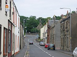
 East end of the High Street | |
| Location | |
| Grid reference: | NS353586 |
| Location: | 55°47’33"N, 4°37’43"W |
| Data | |
| Population: | 2,628 (2001) |
| Postcode: | PA12 |
| Dialling code: | 01505 |
| Local Government | |
| Council: | Renfrewshire |
| Parliamentary constituency: |
Paisley & Renfrewshire South |
Lochwinnoch is a village in Renfrewshire, on the banks of Castle Semple Loch and the River Calder. Lochwinnoch today is chiefly a residential commuter village serving nearby urban centres such as Glasgow and Paisley.
History
Lochwinnoch is first recorded in the 12th Century as a parish under the higher control of Paisley and Renfrew, but the area has been inhabited since the Neolithic period. The village's name probably derives from the Gaelic Loch eanach meaning 'loch of the birds', though local tradition attributes it to St Winnoc.

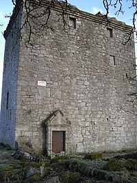
Built not far from the village of Lochwinnoch, Barr Castle is a 15th-century keep which was altered in the 16th century (and probably later, too). The gables of the castle have collapsed, apart from the chimney stack which juts up into the sky. Not much survives of the former courtyard of the castle. The main hall was on the first floor, reached by a turnpike stair, which continued to the rooms on the upper floors. It is clearly visible from the A760 road going south from the village to Kilbirnie. It was built by the Glen family but passed in the late 16th century to the Hamiltons of Ferguslie. A door lintel has a date of 1680 and the initials L.H./I.C. The family abandoned it in the 18th century in favour of a new house.
The family, variously known as Sempill, Sempil, Sempel and Semple, had probably owned estates in the area from as early as the 13th century. Robert Semple, Steward of the barony of Renfrew during the reign of Alexander II, was recorded as living in Elliston Castle, whose ruins lie near Howwood. At some point, probably in the 15th century, the family built a tower keep at the east end of the north shore of the Loch. The Semples of Elliston fought for Robert the Bruce and were appointed Hereditary Sheriffs of Renfrewshire and Hereditary Baillies of Paisley. They were later designated as Lords Semple.
The Semples steadily grew in power to become the Steward's hereditary Baillies of Renfrewshire. Their extensive land holdings, Castle Semple, constituted some areas of Lochwinnoch and its hinterland.
In 1504 John, the first Lord Semple, built the Lochwinnoch Collegiate Church, which became one of Scotland's finest church schools. Its ruins can be found in Parkhill woods on the edge of the village. John was killed at the Battle of Flodden.
In 1727 the Semples sold the estate to the MacDowalls of Garthland. Their mansion house burned down in 1924. Castle Semple House remains only as ruined buildings, such as the west gate, the garden wall, and a hexagonal building known as The Temple, which was built in 1770 on a hill overlooking the Loch.
In 1795, nine mills were built in Lochwinnoch. The village developed mainly to accommodate the work force.[1] As such, the village was first established as a planned community, rather than one evolving over time.
Furniture manufacturers became established in the village in the 19th century. Lochwinnoch-made furniture was to be found on the great Clyde-built liners of the early 20th century, such as the Lusitania, Queen Mary, Queen Elizabeth and the RMS RMS Titanic.
Today, Lochwinnoch chiefly serves as a residential village, as well as a satellite to the major city of Glasgow. In 1972, a number of buildings in the village were brought within a Lochwinnoch conservation area administered by the local authority.
Churches

The early 18th-century St John's Church, also known as 'Auld Simon' (whose front gable still stands at the eastern end of the High Street), was probably built on the site of a pre-Reformation church dating to the Middle Ages. It is dedicated to St John, hence the name of Johnshill, more properly St John's Hill, and St John's well, located in the garden adjacent to the Church Yard.
Auld Simon's early 19th-century replacement, the Church of Scotland Parish Church, complements the formal open space of Harvey Square, on Church Street.
There are three churches in the village:
- Church of Scotland: Lochwinnoch Parish Church on Church Street
- United Free Church of Scotland: Calder United Free Church, also of Church Street
- Roman Catholic: Our Lady of Fatima
History of the lochs
Lochwinnoch stands next to Castle Semple Loch. There is a long history of drainage schemes and farming operations in the Lochwinnoch area, with co-ordinated attempts dating from about 1691 by Lord Sempill, followed by Colonel McDowal of Castle Sempil in 1774, James Adams of Burnfoot, and by others.[2] Until these drainage works there was one big loch consisting of Castle Semple loch, Barr loch and, in times of flooding, Kilbirnie Loch. Early writers such as Boece, Hollings and Petruccio Ubaldini regarded the three lochs as one, usually applying the name 'Garnoth' or 'Garnott'.[2]
Therefore, the two lochs of today, Castle Semple and Barr Lochs, lie in an area covered by one large loch which may have been known as ‘Loch Winnoch’ until the end of the 18th century when silt brought down by the River Calder divided the one loch into two, creating Castle Semple and Barr Loch as separate entities.[3]
Places of interest

The loch plays host to a variety of watersports, being part of the Clyde Muirshiel Regional Park and an RSPB bird sanctuary is nearby.
There are three public houses in Lochwinnoch; the Corner Bar, the Brown Bull and the Three Churches Inn (previously the Garthland Arms). There is also a cafe, the Junction Bistro located at the cross, and a restaurant at the Golf Course which is open to non-members. Lochwinnoch Golf Club (eighteen holes) is on Burnfoot Road.
Pictures
-
Weather vane on St John's Kirk
-
Memorial to the MacDowalls of Garthland
Outside links
| ("Wikimedia Commons" has material about Lochwinnoch) |
References
- ↑ "Historical perspective for Lochwinnoch", Scottish Places]
- ↑ 2.0 2.1 Dobie, Page 315
- ↑ Scottish Natural Heritage Retrieved : 2010-10-24
- Dobie, James D. (ed Dobie, J.S.) (1876). Cunninghame, Topographized by Timothy Pont 1604–1608, with continuations and illustrative notices. Glasgow: John Tweed


