Difference between revisions of "Castleton, Perthshire"
From Wikishire
(Created page with "{{Infobox town |name=Castleton |county= Perthshire |picture=Farm at Lower Borland Park - geograph.org.uk - 397831.jpg |picture caption=Lower Borland Park, Castleton |os grid r...") |
(No difference)
|
Latest revision as of 06:29, 12 April 2023
| Castleton | |
| Perthshire | |
|---|---|
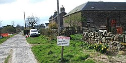
 Lower Borland Park, Castleton | |
| Location | |
| Grid reference: | NN937132 |
| Location: | 56°17’58"N, 3°43’6"W |
| Data | |
| Post town: | Auchterarder |
| Postcode: | PH3 |
| Local Government | |
| Council: | Perth and Kinross |
Castleton is a hamlet strung along a single local road, Castleton Road, running north out of Auchterarder towards Tullibardine, in Perthshire.
The hamlet takes its name from Auchterarder Castle, the remains of which are to the east of the hamlet.