Bleadon: Difference between revisions
Created page with "{{Infobox town |county=Somerset |picture=Bleadonchurch.jpg |picture caption=Church of St Peter and St Paul |latitude=51.3082 |longitude=-2.9448 |population=1,079 |census year=..." |
m →History: clean up, replaced: medieval → mediæval |
||
| Line 25: | Line 25: | ||
The village cross<ref>{{cite web | title=Village Cross | work=Images of England | url=http://www.imagesofengland.org.uk/details/default.aspx?id=33612 | accessdate=11 February 2007}}</ref> and well<ref>{{cite web | title=Village Well | work=Images of England | url=http://www.imagesofengland.org.uk/details/default.aspx?id=33611 | accessdate=11 February 2007}}</ref> are listed buildings. | The village cross<ref>{{cite web | title=Village Cross | work=Images of England | url=http://www.imagesofengland.org.uk/details/default.aspx?id=33612 | accessdate=11 February 2007}}</ref> and well<ref>{{cite web | title=Village Well | work=Images of England | url=http://www.imagesofengland.org.uk/details/default.aspx?id=33611 | accessdate=11 February 2007}}</ref> are listed buildings. | ||
Bleadon lies on the [[River Axe (Bristol Channel)|River Axe]] and had been a small port, sometimes known as Lympsham Wharf, for many years, with the arrival of the railway in 1841 making this the furthest navigable point. It was last used, by the ketch ''Democrat'', in 1942.<ref name="somharbours">{{cite book |title=Somerset Harbours |last=Farr |first=Grahame |authorlink= |author2= |year=1954 |publisher=Christopher Johnson |location=London |isbn= |page=65 }}</ref> An Act of 1915 authorised the drainage of the river and installation of a flood gate at Bleadon,<ref>{{cite book |last=Toulson |first=Shirley |authorlink= |author2= |title=The Mendip Hills: A Threatened Landscape |year=1984 |publisher=Victor Gollancz |location=London |isbn=0-575-03453-X }}</ref> although attempts to control the water had occurred on Bleadon Level since | Bleadon lies on the [[River Axe (Bristol Channel)|River Axe]] and had been a small port, sometimes known as Lympsham Wharf, for many years, with the arrival of the railway in 1841 making this the furthest navigable point. It was last used, by the ketch ''Democrat'', in 1942.<ref name="somharbours">{{cite book |title=Somerset Harbours |last=Farr |first=Grahame |authorlink= |author2= |year=1954 |publisher=Christopher Johnson |location=London |isbn= |page=65 }}</ref> An Act of 1915 authorised the drainage of the river and installation of a flood gate at Bleadon,<ref>{{cite book |last=Toulson |first=Shirley |authorlink= |author2= |title=The Mendip Hills: A Threatened Landscape |year=1984 |publisher=Victor Gollancz |location=London |isbn=0-575-03453-X }}</ref> although attempts to control the water had occurred on Bleadon Level since mediæval times, including an early windmill, in 1613, to pump water into the sea from behind a sea wall.<ref name="havinden">{{cite book|last=Havinden|first=Michael|title=The Somerset Landscape|year=1982|publisher=Hodder and Stoughton|location=London|series=The making of the English landscape|pages=150–155|isbn=0-340-20116-9}}</ref> | ||
==Church== | ==Church== | ||
Latest revision as of 11:55, 30 January 2021
| Bleadon | |
| Somerset | |
|---|---|
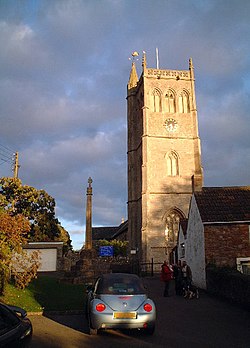
 Church of St Peter and St Paul | |
| Location | |
| Grid reference: | ST341570 |
| Location: | 51°18’30"N, 2°56’41"W |
| Data | |
| Population: | 1,079 (2011[1]) |
| Post town: | Weston-super-Mare |
| Postcode: | BS24 |
| Dialling code: | 01934 |
| Local Government | |
| Council: | North Somerset |
| Parliamentary constituency: |
Weston-super-Mare |
Bleadon is a village and parish in the Winterstoke hundred of Somerset. It is about four miles south of Weston-super-Mare and, according to the 2011 census, has a population of 1,079.[1]
History
Bleadon was listed in the Domesday Book of 1086 as Bledone, meaning 'The coloured hill' from the Old English bleo 'coloured' and dun.[2][3]
Just to the north of the village is Bleadon Hill, a 33-acre geological Site of Special Scientific Interest.
There is evidence or agricultural use of the land in the mediæval period and possibly from Roman times.[4]
The village cross[5] and well[6] are listed buildings.
Bleadon lies on the River Axe and had been a small port, sometimes known as Lympsham Wharf, for many years, with the arrival of the railway in 1841 making this the furthest navigable point. It was last used, by the ketch Democrat, in 1942.[7] An Act of 1915 authorised the drainage of the river and installation of a flood gate at Bleadon,[8] although attempts to control the water had occurred on Bleadon Level since mediæval times, including an early windmill, in 1613, to pump water into the sea from behind a sea wall.[9]
Church
The Church of St Peter and St Paul dominates the village.[10] It was built in the 14th century (dedicated in 1317), being restored and the chancel shortened in the mid 19th century. It is a Grade-I listed building.[11] The tower contains five bells dating from 1711 and made by Edward Bilbie of the Bilbie family.[12]
References
| ("Wikimedia Commons" has material about Bleadon) |
- ↑ 1.0 1.1 "2011 Census Profile" (Excel). North Somerset Council. Archived from the original on 4 January 2014. https://web.archive.org/web/20140104204530/http://www.n-somerset.gov.uk/Environment/Planning_policy_and-research/researchandmonitoring/Documents/North%20Somerset%20Small%20area%20geography%20profiles%20tool.xls. Retrieved 4 January 2014.
- ↑ Robinson, Stephen (1992). Somerset Place Names. Wimborne, Dorset: The Dovecote Press Ltd. ISBN 1-874336-03-2.
- ↑ "Autumn newsletter 2007" (PDF). Mendip Hills AONB. Archived from the original on 28 November 2007. https://web.archive.org/web/20071128102641/http://www.mendiphillsaonb.org.uk/publications/up_081015_autumn07_lo.pdf. Retrieved 25 September 2007.
- ↑ "Mendip Hills An Archaeological Survey of the Area of Outstanding Natural Beauty". Somerset Council Archaeological Projects. http://www1.somerset.gov.uk/archives/hes/downloads/HES_MendipAONB.pdf. Retrieved 16 January 2011.
- ↑ "Village Cross". Images of England. http://www.imagesofengland.org.uk/details/default.aspx?id=33612. Retrieved 11 February 2007.
- ↑ "Village Well". Images of England. http://www.imagesofengland.org.uk/details/default.aspx?id=33611. Retrieved 11 February 2007.
- ↑ Farr, Grahame (1954). Somerset Harbours. London: Christopher Johnson. p. 65.
- ↑ Toulson, Shirley (1984). The Mendip Hills: A Threatened Landscape. London: Victor Gollancz. ISBN 0-575-03453-X.
- ↑ Havinden, Michael (1982). The Somerset Landscape. The making of the English landscape. London: Hodder and Stoughton. pp. 150–155. ISBN 0-340-20116-9.
- ↑ Atthill, Robin (1976). Mendip: A new study. Newton Abbot, Devon: David & Charles. ISBN 0-7153-7297-1.
- ↑ "Church of St Peter and St Paul". Images of England. Archived from the original on 2 October 2012. https://web.archive.org/web/20121002233829/http://www.imagesofengland.org.uk/details/default.aspx?id=33613. Retrieved 11 February 2007.
- ↑ Moore, James; Roy Rice; Ernest Hucker (1995). Bilbie and the Chew Valley clock makers. The authors. ISBN 0-9526702-0-8.
