Difference between revisions of "Ingst"
From Wikishire
(Created page with "{{Infobox town |name=Ingst |county=Gloucestershire |picture=Greenditch Farm - geograph.org.uk - 381053.jpg |picture caption=Greenditch Farm, Ingst |os grid ref=ST581877 |latit...") |
(No difference)
|
Latest revision as of 22:55, 29 November 2019
| Ingst | |
| Gloucestershire | |
|---|---|
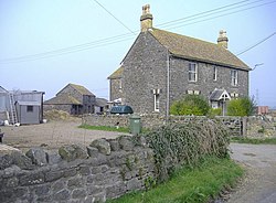
 Greenditch Farm, Ingst | |
| Location | |
| Grid reference: | ST581877 |
| Location: | 51°35’13"N, 2°36’18"W |
| Data | |
| Postcode: | BS35 |
| Local Government | |
| Council: | South Gloucestershire |
Ingst is a hamlet in the parish of Olveston in Gloucestershire. It consists of just five households, most of which are farms with cattle.
The M48 motorway passes by the hamlet.
Outside links
| ("Wikimedia Commons" has material about Ingst) |