Sutton-on-Trent: Difference between revisions
Created page with "{{Infobox town |county=Nottingham |picture=Sutton-on-Trent - Vine House.JPG |picture caption=Vine House |latitude=53.185 |longitude=-0.808 |population=1331 |census year==2011..." |
mNo edit summary |
||
| Line 14: | Line 14: | ||
}} | }} | ||
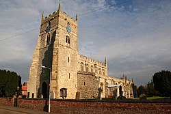
[[File:All Saints' church, Sutton on Trent - geograph.org.uk - 92365.jpg|right|thumb|250px| All Saints' church]] | [[File:All Saints' church, Sutton on Trent - geograph.org.uk - 92365.jpg|right|thumb|250px| All Saints' church]] | ||
'''Sutton-on-Trent''' is a large village and parish in the [ | '''Sutton-on-Trent''' is a large village and parish in the [[Thurgarton Wapentake]] of [[Nottinghamshire]], situated on the Great North Road, and on the west bank of the Trent. | ||
The village contains 2,450 acres of land and according to the 2001 census it had a population of 1,327,<ref>[http://www.neighbourhood.statistics.gov.uk/dissemination/LeadTableView.do?a=3&b=798468&c=sutton&d=16&e=15&g=479477&i=1001x1003x1004&m=0&r=1&s=1206897338528&enc=1&dsFamilyId=779 "Area: Sutton-on-Trent CP (Parish)"]</ref> increasing marginally to 1,331 at the 2011 census.<ref>{{cite web|url=http://www.neighbourhood.statistics.gov.uk/dissemination/LeadKeyFigures.do?a=7&b=11129335&c=sutton-on-trent+cp&d=16&e=62&g=6457898&i=1001x1003x1032x1004&m=0&r=1&s=1460734733719&enc=1|title=Civil Parish population 2011|accessdate=15 April 2016|publisher=Office for National statistics|work=Neighbourhood Statistics}}</ref> | The village contains 2,450 acres of land and according to the 2001 census it had a population of 1,327,<ref>[http://www.neighbourhood.statistics.gov.uk/dissemination/LeadTableView.do?a=3&b=798468&c=sutton&d=16&e=15&g=479477&i=1001x1003x1004&m=0&r=1&s=1206897338528&enc=1&dsFamilyId=779 "Area: Sutton-on-Trent CP (Parish)"]</ref> increasing marginally to 1,331 at the 2011 census.<ref>{{cite web|url=http://www.neighbourhood.statistics.gov.uk/dissemination/LeadKeyFigures.do?a=7&b=11129335&c=sutton-on-trent+cp&d=16&e=62&g=6457898&i=1001x1003x1032x1004&m=0&r=1&s=1460734733719&enc=1|title=Civil Parish population 2011|accessdate=15 April 2016|publisher=Office for National statistics|work=Neighbourhood Statistics}}</ref> | ||
It is located eight miles north of [[Newark-on-Trent]], which takes approximately 20 minutes to reach by car, and 10 miles south of Retford, which takes approximately 22 minutes to reach by car. | It is located eight miles north of [[Newark-on-Trent]], which takes approximately 20 minutes to reach by car, and 10 miles south of [[Retford]], which takes approximately 22 minutes to reach by car. | ||
Sutton Mill was a stone-built tower windmill, built in 1825. It was owned by the Bingham family of Grassthorpe from the 1860s until 1984. The four-storey tower has been converted to a house.<ref>Shaw, T. (1995). ''Windmills of Nottinghamshire''. Page 37. Nottingham: Nottinghamshire Council. {{ISBN|0-900986-12-3}}</ref> | Sutton Mill was a stone-built tower windmill, built in 1825. It was owned by the Bingham family of Grassthorpe from the 1860s until 1984. The four-storey tower has been converted to a house.<ref>Shaw, T. (1995). ''Windmills of Nottinghamshire''. Page 37. Nottingham: Nottinghamshire Council. {{ISBN|0-900986-12-3}}</ref> | ||
==History== | ==History== | ||
Dredging of the [[River Trent|river]] has revealed | Dredging of the [[River Trent|river]] has revealed fossilised mammoth's teeth and tusks, Roman and Anglo Saxon pottery.<ref>[http://www.bbc.co.uk/history/domesday/dblock/GB-476000-363000/page/19 Domesday Book Reloaded], at [[BBC]].co.uk.</ref> The town is mentioned in the [[Domesday Book]] and a Norman church was built in the 13th Century. | ||
In May 1686 the manor and lordship of Sutton-on-Trent were sold to Richard Levett, later Lord Mayor of London, and his wife Mary.<ref>[http://nottingham.ac.uk/mss/collections/online-mss-catalogues/cats/denison_de.html Catalogue of Denison Estate Papers in the Denison Collection, University of Notthingham, nottingham.ac.uk]</ref><ref>[https://books.google.com/books?id=OjbGAAAAMAAJ&pg=PA261&lpg=PA261&dq=%22richard+levett%22+portrait&source=bl&ots=AElONlTXcs&sig=glL_sjEhPdYAY6n2EOVhO19AXBQ&hl=en&ei=SACLSpfQBoG-sgO5uLjWDQ&sa=X&oi=book_result&ct=result&resnum=5#v=onepage&q=%22richard%20levett%22%20portrait&f=false The Home Counties Magazine: Devoted to the Topography of London, Middlesex, Essex, Herts, Bucks, Berks, Surrey and Kent, Vol. X, W. Paley Baildon (ed.), Reynell & Son, London, 1908]</ref> | In May 1686 the manor and lordship of Sutton-on-Trent were sold to Richard Levett, later Lord Mayor of London, and his wife Mary.<ref>[http://nottingham.ac.uk/mss/collections/online-mss-catalogues/cats/denison_de.html Catalogue of Denison Estate Papers in the Denison Collection, University of Notthingham, nottingham.ac.uk]</ref><ref>[https://books.google.com/books?id=OjbGAAAAMAAJ&pg=PA261&lpg=PA261&dq=%22richard+levett%22+portrait&source=bl&ots=AElONlTXcs&sig=glL_sjEhPdYAY6n2EOVhO19AXBQ&hl=en&ei=SACLSpfQBoG-sgO5uLjWDQ&sa=X&oi=book_result&ct=result&resnum=5#v=onepage&q=%22richard%20levett%22%20portrait&f=false The Home Counties Magazine: Devoted to the Topography of London, Middlesex, Essex, Herts, Bucks, Berks, Surrey and Kent, Vol. X, W. Paley Baildon (ed.), Reynell & Son, London, 1908]</ref> | ||
Latest revision as of 13:23, 12 April 2019
| Sutton-on-Trent | |
| Nottinghamshire | |
|---|---|
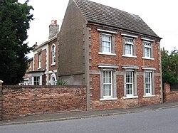
 Vine House | |
| Location | |
| Grid reference: | SK794658 |
| Location: | 53°11’6"N, -0°48’29"W |
| Data | |
| Population: | 1,331 (=2011) |
| Post town: | Newark |
| Postcode: | NG23 |
| Dialling code: | 01636 |
| Local Government | |
| Council: | Newark and Sherwood |

Sutton-on-Trent is a large village and parish in the Thurgarton Wapentake of Nottinghamshire, situated on the Great North Road, and on the west bank of the Trent.
The village contains 2,450 acres of land and according to the 2001 census it had a population of 1,327,[1] increasing marginally to 1,331 at the 2011 census.[2]
It is located eight miles north of Newark-on-Trent, which takes approximately 20 minutes to reach by car, and 10 miles south of Retford, which takes approximately 22 minutes to reach by car.
Sutton Mill was a stone-built tower windmill, built in 1825. It was owned by the Bingham family of Grassthorpe from the 1860s until 1984. The four-storey tower has been converted to a house.[3]
History
Dredging of the river has revealed fossilised mammoth's teeth and tusks, Roman and Anglo Saxon pottery.[4] The town is mentioned in the Domesday Book and a Norman church was built in the 13th Century.
In May 1686 the manor and lordship of Sutton-on-Trent were sold to Richard Levett, later Lord Mayor of London, and his wife Mary.[5][6]
In Far Holme Lane can be found the Old Manse and the Old Chapel - these are the remnants of the small Particular Baptist church that existed here from 1822 to the 1900s. Although some Baptist historical writing suggests that the church was founded by Alexander Jamieson with the support of the wealthy Haldane brothers of Glasgow in the period 1800-1810, there is fairly convincing evidence that it was actually 'planted' by the Collingham Baptist congregation under William Nichols. George Pope may then have become its own minister - before himself moving to Collingham. Nichols was active in the village as early as 1809.
Although the Baptist denomination has long since ceased to be active in the village, an interesting coincidence is that the 2018 residents of the old chapel were actually married in a Baptist church.
In 1870–72,[7] Sutton on Trent was described as:
- A village and a parish in Southwell district, Notts. The village stands 1½ mile N by E of Carlton r. station, and 8 N of Newark; was once a market-town; is a polling place; and has a post-office under Newark. The parish comprises 2,930 acres. Real property, £6,753. Pop. in 1851, 1,262; in 1861, 1,147. Houses, 281. The manor belongs to the Right Hon. J. E. Denison. There are corn mills. The living. is a vicarage in the diocese of Lincoln. Value, £280. Patron, Rev.Graystone. The church was repaired in 1848. There are chapels for Independents, Baptists, and Wesleyans, a slightly endowed school, and charities £5.[8]
A Board School was leased from the Church School Trustees and endowed in 1816, and Sutton Mill a stone tower windmill built in 1825, (It is now a residence) and by 1900 the area was known for its basket making. A feastival is still held on the first of November each year.[9][10]
References
- ↑ "Area: Sutton-on-Trent CP (Parish)"
- ↑ "Civil Parish population 2011". Neighbourhood Statistics. Office for National statistics. http://www.neighbourhood.statistics.gov.uk/dissemination/LeadKeyFigures.do?a=7&b=11129335&c=sutton-on-trent+cp&d=16&e=62&g=6457898&i=1001x1003x1032x1004&m=0&r=1&s=1460734733719&enc=1. Retrieved 15 April 2016.
- ↑ Shaw, T. (1995). Windmills of Nottinghamshire. Page 37. Nottingham: Nottinghamshire Council. ISBN 0-900986-12-3
- ↑ Domesday Book Reloaded, at BBC.co.uk.
- ↑ Catalogue of Denison Estate Papers in the Denison Collection, University of Notthingham, nottingham.ac.uk
- ↑ The Home Counties Magazine: Devoted to the Topography of London, Middlesex, Essex, Herts, Bucks, Berks, Surrey and Kent, Vol. X, W. Paley Baildon (ed.), Reynell & Son, London, 1908
- ↑ Sutton on Trent Nottinghamshire – at A Vision of Britain through Time.
- ↑ John Marius Wilson's Imperial Gazetteer of England and Wales.
- ↑ Sutton on Trent, at GenUK.
- ↑ Cornelius Brown, A History of Nottinghamshire, (1896).
Outside links
| ("Wikimedia Commons" has material about Sutton-on-Trent) |
