Stapleford Abbotts: Difference between revisions
m clean up, typos fixed: As a result → As a result, |
No edit summary |
||
| Line 16: | Line 16: | ||
|website=[http://www.staplefordabbotts-pc.gov.uk Stapleford Abbotts Town Council] | |website=[http://www.staplefordabbotts-pc.gov.uk Stapleford Abbotts Town Council] | ||
}} | }} | ||
'''Stapleford Abbotts''' (the suffix is sometimes spelled ‘Abbots’) is a village in [[Essex]]found some | '''Stapleford Abbotts''' (the suffix is sometimes spelled ‘Abbots’) is a village in [[Essex]], found some six miles south-west of [[Chipping Ongar]] and five miles north of [[Romford]]. It is within the ring of the [[M25 motorway]]. The whole parish covers an area of {{convert|957|ha|0|x}} and had a population of 959 in 2001. | ||
The village is in the [[Ongar Hundred]]. | The village is in the [[Ongar Hundred]]. | ||
Latest revision as of 21:16, 16 March 2019
| Stapleford Abbotts | |
| Essex | |
|---|---|
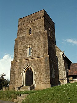
 Church of St Mary | |
| Location | |
| Grid reference: | TQ505955 |
| Location: | 51°39’7"N, -0°9’47"E |
| Data | |
| Population: | 959 (2001) |
| Post town: | Romford |
| Postcode: | RM4 |
| Dialling code: | 01708 |
| Local Government | |
| Council: | Epping Forest |
| Parliamentary constituency: |
Brentwood and Ongar |
| Website: | Stapleford Abbotts Town Council |
Stapleford Abbotts (the suffix is sometimes spelled ‘Abbots’) is a village in Essex, found some six miles south-west of Chipping Ongar and five miles north of Romford. It is within the ring of the M25 motorway. The whole parish covers an area of 2,365 acres and had a population of 959 in 2001.
The village is in the Ongar Hundred.
Round about the village
The parish is mostly rural and agricultural with a scattering of farms and cottages, much of it is Metropolitan Green Belt protected land. The northern boundary of the parish is formed by the River Roding and the remainder of the parish is crossed by a number of streams that feed into it. As a result, the terrain is hilly, though never over 300 feet above sea level.
The village itself consists of a straggle of mostly 20th-century housing stretching for about a mile along the Romford to Ongar road from the boundary with Havering-atte-Bower. The mediæval church (largely rebuilt in the 19th century) is in a relatively isolated position a further mile away from what is now the village, reflecting the fact that there was no single nucleus of settlement until the 20th century.[1]
Aside from the village of Stapleford Abbotts the parish also includes the hamlets of Bournebridge, Nuper's Hatch and Passingford Bridge.
Stapleford Aerodrome is to the north of the village.
The nearest railway station is at Romford. There are frequent services from Romford Station to London and East Anglia.
History
The name "Stapleford" is found in several counties. The village has the suffix "Abbotts" because the principal manor was owned by the Abbey of Bury St Edmunds throughout the Middle Ages, until the Dissolution of the Monasteries. A story is recorded in the abbey's registers that the lord of the manor was miraculously cured of a lingering illness in 1013 by the body of St Edmund as it passed by on its way back to Bury Abbey from London. In gratitude for being cured he gave the manor to the abbey, either then or some time later.[2]
The population rose from 320 in 1801 to 507 in 1831, then fluctuated within that range until 1921 when it was 391. In the 20th century there has been a gradual increase with the building of houses from the 1930s onwards (in 1951 the population was 731).[1]
See also
Outside links
References
- ↑ 1.0 1.1 Stapleford Abbots: Introduction' - A History of the County of Essex: Volume 4: Ongar Hundred (1956), pp. 222-23
- ↑ Stapleford Abbots: Manors - A History of the County of Essex: Volume 4: Ongar Hundred (1956), pp. 223-28