Vange: Difference between revisions
Created page with "{{infobox town |county=Essex |latitude=51.557891 |longitude=0.474361 |population=10,048 |census year=2011 |picture=Vange Church.jpg |picture caption=All Saints Church, Vange |..." |
No edit summary |
||
| Line 12: | Line 12: | ||
|LG district=Basildon | |LG district=Basildon | ||
}} | }} | ||
'''Vange''' is a an ancient parish in the Barnstable | '''Vange''' is a an ancient parish in the [[Barnstable Hundred]] of [[Essex]] that forms a suburb of [[Basildon]]. As it is much smaller than Basildon, [[Laindon]] and [[Pitsea]], it does not have its own town centre or railway station.<ref>[http://www.basildon.com/history/vange/vange.html History of Vange]</ref> The London Road (B1464) is the main road through Vange and used to be part of the A13 until it was bypassed in the 1970s. The population of the Vange ward within the Basildon district taken at the 2011 Census was 10,048.<ref>{{cite web|url=http://www.neighbourhood.statistics.gov.uk/dissemination/LeadKeyFigures.do?a=7&b=13691868&c=Vange&d=14&e=62&g=6422605&i=1001x1003x1032x1004&m=0&r=1&s=1473255587031&enc=1|title=Basildon Ward population 2011|accessdate=7 September 2016|publisher= Office for National Statistics |work=Neighbourhood Statistics}}</ref> | ||
Vange Hill Open Space is 30 acres of former plotlands lying next to Basildon golf course. | Vange Hill Open Space is 30 acres of former plotlands lying next to Basildon golf course. | ||
| Line 25: | Line 25: | ||
*The Five Bells | *The Five Bells | ||
== | ==Outside links== | ||
* [http://www.basildonheritage.org.uk/ Basildon Heritage] | * [http://www.basildonheritage.org.uk/ Basildon Heritage] | ||
* [http://basildonhistory.wix.com/essex#!vange/c1pqx Basildon Borough History - Vange] | * [http://basildonhistory.wix.com/essex#!vange/c1pqx Basildon Borough History - Vange] | ||
Latest revision as of 12:32, 2 August 2018
| Vange | |
| Essex | |
|---|---|
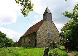
 All Saints Church, Vange | |
| Location | |
| Location: | 51°33’28"N, -0°28’28"E |
| Data | |
| Population: | 10,048 (2011) |
| Post town: | Basildon |
| Postcode: | SS16 |
| Dialling code: | 01268 |
| Local Government | |
| Council: | Basildon |
Vange is a an ancient parish in the Barnstable Hundred of Essex that forms a suburb of Basildon. As it is much smaller than Basildon, Laindon and Pitsea, it does not have its own town centre or railway station.[1] The London Road (B1464) is the main road through Vange and used to be part of the A13 until it was bypassed in the 1970s. The population of the Vange ward within the Basildon district taken at the 2011 Census was 10,048.[2]
Vange Hill Open Space is 30 acres of former plotlands lying next to Basildon golf course.
Vange Marshes is a wetland habitat.
Church
The earliest parts of All Saints Church date from the late 12th century, with alterations from subsequent centuries. The last were in 1837. It is built of stone, flint and other masonry, with bands of brickwork alternating with tufa and rubble walling. A bellcote that was refashioned in 1816 tops it off.
Public Houses
- The Old Barge Inn
- The Five Bells
Outside links
References
- ↑ History of Vange
- ↑ "Basildon Ward population 2011". Neighbourhood Statistics. Office for National Statistics. http://www.neighbourhood.statistics.gov.uk/dissemination/LeadKeyFigures.do?a=7&b=13691868&c=Vange&d=14&e=62&g=6422605&i=1001x1003x1032x1004&m=0&r=1&s=1473255587031&enc=1. Retrieved 7 September 2016.