Difference between revisions of "Abbey Dore"
From Wikishire
(Created page with "{{Infobox town |county=Hereford |picture=Abbey Dore Court Gardens.jpg |picture caption=The gardens at Abbey Dore Court |os grid ref=SD3830 |latitude=51.970 |longitude=-2.895 |...") |
(No difference)
|
Latest revision as of 10:26, 7 April 2018
| Abbey Dore | |
| Herefordshire | |
|---|---|
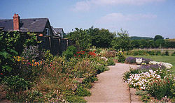
 The gardens at Abbey Dore Court | |
| Location | |
| Grid reference: | SD3830 |
| Location: | 51°58’12"N, 2°53’42"W |
| Data | |
| Population: | 385 (2011[1]) |
| Post town: | Hereford |
| Postcode: | HR2 |
| Dialling code: | 01981 |
| Local Government | |
| Council: | Herefordshire |
| Parliamentary constituency: |
Hereford and South Herefordshire |
Abbey Dore is a village and parish in Herefordshire, known for Dore Abbey, a 12th-century Cistercian abbey, expanded in the 13th century. The village is situated in the Golden Valley, and has a population of 342,[2] increasing to 385 at the 2011 Census. Abbey Dore Court has large gardens open to the public in spring and summer.
Abbeydore railway station closed in 1941. It was on the Great Western Railway branch line linking Pontrilas and Hay-on-Wye.
References
- ↑ "Civil Parish population 2011". http://www.neighbourhood.statistics.gov.uk/dissemination/LeadKeyFigures.do?a=7&b=11119761&c=Abbey+Dore&d=16&e=62&g=6385883&i=1001x1003x1032x1004&m=0&r=1&s=1445974381125&enc=1. Retrieved 27 October 2015.
- ↑ "Parish Headcounts: Herefordshire". Neighbourhood Statistics. Office for National Statistics. http://www.neighbourhood.statistics.gov.uk/dissemination/viewFullDataset.do?instanceSelection=03070&productId=779&$ph=60_61&datasetInstanceId=3070&startColumn=1&numberOfColumns=8&containerAreaId=790292. Retrieved 16 September 2011.
Outside links
| ("Wikimedia Commons" has material about Abbey Dore) |