Hill of Stake: Difference between revisions
Jump to navigation
Jump to search
Created page with '{{Infobox hill |name=Hill of Stake |county 1=Renfrewshire |county 2=Ayrshire |picture=Hill of Stake - geograph.org.uk - 30223.jpg |picture caption=Hill of Stake - geograph.org.uk…' |
No edit summary |
||
| Line 15: | Line 15: | ||
*[http://www.geograph.org.uk/photo/429731 Hill of Stake on Geograph.org.uk] | *[http://www.geograph.org.uk/photo/429731 Hill of Stake on Geograph.org.uk] | ||
{{DEFAULTSORT:Stake, Hill of}} | |||
[[Category:County tops]] | [[Category:County tops]] | ||
Revision as of 20:36, 22 October 2011
| Hill of Stake | |
| Renfrewshire, Ayrshire | |
|---|---|
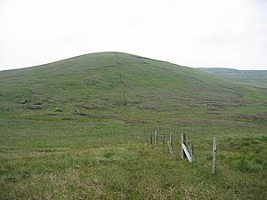
 Hill of Stake - geograph.org.uk - 30223.jpg | |
| Summit: | 1,713 feet NS273630 |
Hill of Stake is a hill on the boundary between Ayrshire and Renfrewshire. It is the county top of Renfrewshire, its summit reaching 1,713 feet above sea level.
The hill is within the Clyde Muirshiel Regional Park, and is the highest point of the park also.