Hale Barns: Difference between revisions
Jump to navigation
Jump to search
Created page with "{{Infobox town |name=Hale Barns |county=Cheshire |picture=Village pub, Hale Barns (geograph 4117025).jpg |picture caption=Village pub |latitude=53.366 |longitude=-2.313 |popul..." |
No edit summary |
||
| Line 14: | Line 14: | ||
|constituency=Altrincham and Sale West | |constituency=Altrincham and Sale West | ||
}} | }} | ||
'''Hale Barns''' is a suburban village in [[Cheshire]], located on the very edge of the conurbation of towns centred on [[Manchester]]. Timperley is contiguous with | '''Hale Barns''' is a suburban village in [[Cheshire]], located on the very edge of the conurbation of towns centred on [[Manchester]]. Timperley is contiguous with [[Hale]] to the northwest, while parkland lies to the northwest and to the south lies open country. | ||
{{stub}} | {{stub}} | ||
Latest revision as of 21:12, 8 November 2016
| Hale Barns | |
| Cheshire | |
|---|---|
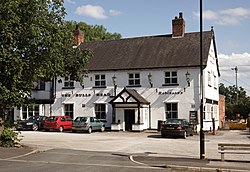
 Village pub | |
| Location | |
| Location: | 53°21’58"N, 2°18’47"W |
| Data | |
| Population: | 9,736 (2011) |
| Post town: | Altrincham |
| Postcode: | WA15 |
| Dialling code: | 0161 |
| Local Government | |
| Council: | Trafford |
| Parliamentary constituency: |
Altrincham and Sale West |
Hale Barns is a suburban village in Cheshire, located on the very edge of the conurbation of towns centred on Manchester. Timperley is contiguous with Hale to the northwest, while parkland lies to the northwest and to the south lies open country.

This Cheshire article is a stub: help to improve Wikishire by building it up.