Chardstock: Difference between revisions
Created page with "{{Infobox town |county=Dorset |latitude =50.835796 |longitude =-2.980691 |population =828 |LG district =East Devon |postcode =EX13 |dialling code =01460 |constituency=East De..." |
No edit summary |
||
| Line 12: | Line 12: | ||
|os grid ref=ST309045 | |os grid ref=ST309045 | ||
}} | }} | ||
'''Chardstock''' is a village and parish in a salient of [[Dorset]] between [[Somerset]] and [[Devon]]. The village is located off the A358 road between [[Chard]] in Somerset and [[Axminster]] in Devon. The parish population at the 2011 Census was 828.<ref>{{cite web|url=http://www.neighbourhood.statistics.gov.uk/dissemination/LeadDatasetList.do?a=7&b=11121792&c=Chardstock&d=16&g=6415494&i=1001x1003x1032&m=0&r=1&s=1424875982841&enc=1&domainId=62|title=Parish population 2011|accessdate= 25 February 2015}}</ref> The parish also contains the hamlets of Bewley Down, Birchill, Burridge, Holy City and Tytherleigh. A detached part of the ancient parish containing the hamlet of Crawley forms the westernmost part of Dorset. | '''Chardstock''' is a village and parish in a salient of [[Dorset]] between [[Somerset]] and [[Devon]]. The village is located off the A358 road between [[Chard]] in Somerset and [[Axminster]] in Devon. The parish population at the 2011 Census was 828.<ref>{{cite web|url=http://www.neighbourhood.statistics.gov.uk/dissemination/LeadDatasetList.do?a=7&b=11121792&c=Chardstock&d=16&g=6415494&i=1001x1003x1032&m=0&r=1&s=1424875982841&enc=1&domainId=62|title=Parish population 2011|accessdate= 25 February 2015}}</ref> The parish also contains the hamlets of Bewley Down, Birchill, Burridge, Holy City and Tytherleigh. A detached part of the ancient parish containing the hamlet of Crawley forms the westernmost part of Dorset proper (albeit that the detached part of the county containing [[Stockwood]] lies farther west). | ||
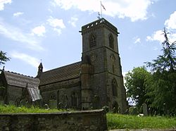
The attractive village is surrounded by farmland and woodland and is within the [[Blackdown Hills]] Area of Outstanding Natural Beauty. The River Kit runs through the village. The village church dates from the 19th Century.<ref>{{IoE|87765}}</ref> The village also has a post office and pub. | The attractive village is surrounded by farmland and woodland and is within the [[Blackdown Hills]] Area of Outstanding Natural Beauty. The River Kit runs through the village. The village church dates from the 19th Century.<ref>{{IoE|87765}}</ref> The village also has a post office and pub. | ||
Revision as of 12:22, 8 February 2016
| Chardstock | |
| Dorset | |
|---|---|

| |
| Location | |
| Grid reference: | ST309045 |
| Location: | 50°50’9"N, 2°58’50"W |
| Data | |
| Population: | 828 |
| Postcode: | EX13 |
| Dialling code: | 01460 |
| Local Government | |
| Council: | East Devon |
| Parliamentary constituency: |
East Devon |
Chardstock is a village and parish in a salient of Dorset between Somerset and Devon. The village is located off the A358 road between Chard in Somerset and Axminster in Devon. The parish population at the 2011 Census was 828.[1] The parish also contains the hamlets of Bewley Down, Birchill, Burridge, Holy City and Tytherleigh. A detached part of the ancient parish containing the hamlet of Crawley forms the westernmost part of Dorset proper (albeit that the detached part of the county containing Stockwood lies farther west).
The attractive village is surrounded by farmland and woodland and is within the Blackdown Hills Area of Outstanding Natural Beauty. The River Kit runs through the village. The village church dates from the 19th Century.[2] The village also has a post office and pub.
The collection of work by Artist Kenneth Butler Evans, cousin of poet William Butler Yeats, is based in the village at the home of his widow, sculptor Ann Ford.
References
- ↑ "Parish population 2011". http://www.neighbourhood.statistics.gov.uk/dissemination/LeadDatasetList.do?a=7&b=11121792&c=Chardstock&d=16&g=6415494&i=1001x1003x1032&m=0&r=1&s=1424875982841&enc=1&domainId=62. Retrieved 25 February 2015.
- ↑ Images of England — details from listed building database (87765)
Outside links
| ("Wikimedia Commons" has material about Chardstock) |
