Kirkharle: Difference between revisions
Created page with "{{Infobox town |name=Kirkharle |county=Northumberland |picture=Geograph-1869828-by-Andrew-Curtis.jpg |picture caption=Kirkharle |os grid ref=NZ015825 |latitude=55.137 |longitu..." |
No edit summary |
||
| Line 14: | Line 14: | ||
|constituency=Hexham | |constituency=Hexham | ||
}} | }} | ||
'''Kirkharle''' (otherwise '''Kirk Harle''') is a hamlet in [[Northumberland]] located about 12 miles west | '''Kirkharle''' (otherwise '''Kirk Harle''') is a hamlet in [[Northumberland]] located about 12 miles west of [[Morpeth]], just to the west of the crossroads of the A696 and B6342 roads. | ||
The village was formerly named 'Herle' (recorded 1177)<ref name=P-NoN&D>''The Place-names of Northumberland and Durham'', Cambridge University Press, pp. 128</ref> The element 'Herle' comes from the Old English "Herela-lea" which means "Herela's Grove" or "herg-leah" which means "temple-grove".<ref>Beckensall, Stan. 'Northumbrian Place-Names: A Guide To The Meaning of Town And Village Names'. Butler Publishing 2004. ISBN 0-946928-41-X. Page 37</ref> Other early forms included Kyrkeherle (c.1250), Kyrkherll (1346) and Kirkehirle (1428).<ref name=P-NoN&D/> Its church has gained it the prefix 'kirk'. | The village was formerly named 'Herle' (recorded 1177)<ref name=P-NoN&D>''The Place-names of Northumberland and Durham'', Cambridge University Press, pp. 128</ref> The element 'Herle' comes from the Old English "Herela-lea" which means "Herela's Grove" or "herg-leah" which means "temple-grove".<ref>Beckensall, Stan. 'Northumbrian Place-Names: A Guide To The Meaning of Town And Village Names'. Butler Publishing 2004. ISBN 0-946928-41-X. Page 37</ref> Other early forms included Kyrkeherle (c.1250), Kyrkherll (1346) and Kirkehirle (1428).<ref name=P-NoN&D/> Its church has gained it the prefix 'kirk'. | ||
Latest revision as of 07:13, 26 January 2016
| Kirkharle | |
| Northumberland | |
|---|---|
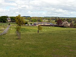
 Kirkharle | |
| Location | |
| Grid reference: | NZ015825 |
| Location: | 55°8’13"N, 1°58’41"W |
| Data | |
| Post town: | Morpeth |
| Postcode: | NE61 |
| Dialling code: | 01830 |
| Local Government | |
| Council: | Northumberland |
| Parliamentary constituency: |
Hexham |
Kirkharle (otherwise Kirk Harle) is a hamlet in Northumberland located about 12 miles west of Morpeth, just to the west of the crossroads of the A696 and B6342 roads.
The village was formerly named 'Herle' (recorded 1177)[1] The element 'Herle' comes from the Old English "Herela-lea" which means "Herela's Grove" or "herg-leah" which means "temple-grove".[2] Other early forms included Kyrkeherle (c.1250), Kyrkherll (1346) and Kirkehirle (1428).[1] Its church has gained it the prefix 'kirk'.
Landmarks
Kirkharle Hall was a country house at Kirkharle, the former seat of the Loraine family, now much reduced and in use as a farmhouse.
A mile to the north of Kirkharle is Little Harle Tower, an 18th and 19th century mansion which incorporates a 15th or 16th century pele tower.[3]
Parish church
The current church, dedicated to St Wilfrid, was built in the fourteenth century. Among the quaint epitaphs in the church upon departed Loraines is the following:
Here lyes the Body of Richard Loraine, Esq., who was a proper handsome man of good sense and behaviour : he dy'd a Batcheler of an Appoplexy walking in a green field near London, October 26th, 1738, in the 38 Year of his Age.[4]
The Loraine Baronets acquired it by marriage the manor from the De Harles who owned it in the 14th century,[4] and derived their name (literally "of Harle") from the village.[5]
Capability Brown
Kirkharle's most famous son is Capability Brown the notable landscape gardener whose father was employed by the Loraines at Kirkharle Hall. The artist and fox hunter Charles Loraine Smith was born to a Loraine and adopted the name of Smith whist a boy.
Outside links
| ("Wikimedia Commons" has material about Kirkharle) |
References
- ↑ 1.0 1.1 The Place-names of Northumberland and Durham, Cambridge University Press, pp. 128
- ↑ Beckensall, Stan. 'Northumbrian Place-Names: A Guide To The Meaning of Town And Village Names'. Butler Publishing 2004. ISBN 0-946928-41-X. Page 37
- ↑ Little Harle Tower - British Listed Buildings
- ↑ 4.0 4.1 Hugill, Robert (1931). Road Guide to Northumberland and The Border. Newcastle upon Tyne: Andrew Reid & Company, Limited. pp. 157–8.
- ↑ The surnames of Scotland: their origin, meaning, and history, George Fraser Black, New York Public Library, 1946, P.344
