Surrey Quays: Difference between revisions
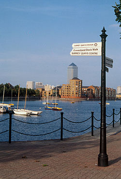
Created page with "{{Infobox town |county=Surrey |latitude=51.500 |longitude= -0.040 |population= |picture=SurreyQuayssign.jpg |picture caption=Greenland Dock, Surrey Quays, in the early 1990s |..." |
|||
| Line 32: | Line 32: | ||
* [http://www.lddc-history.org.uk/surrey.html LDDC Completion Booklet - Surrey Docks] | * [http://www.lddc-history.org.uk/surrey.html LDDC Completion Booklet - Surrey Docks] | ||
* [http://www.theretaildatabase.com/retail%20location.php?ID=134 Surrey Quays Shopping Centre on The Retail Database] | * [http://www.theretaildatabase.com/retail%20location.php?ID=134 Surrey Quays Shopping Centre on The Retail Database] | ||
[[Category:Metropolitan Surrey]] | |||
Latest revision as of 11:17, 25 January 2016
| Surrey Quays | |
| Surrey | |
|---|---|
 Greenland Dock, Surrey Quays, in the early 1990s | |
| Location | |
| Location: | 51°30’0"N, 0°2’24"W |
| Data | |
| Post town: | London |
| Postcode: | SE16 |
| Dialling code: | 020 |
| Local Government | |
| Council: | Southwark |
Surrey Quays is a largely residential area of Rotherhithe in metropolitan Surrey, occupied until 1970 by the Surrey Commercial Docks. The precise boundaries of the area are somewhat amorphous, but it is generally considered to comprise the southern half of the Rotherhithe peninsula from Canada Water to the South Dock.
History
After the closure of the docks, the area remained derelict for over a decade, with much of the warehousing demolished and over 90% of the docks filled in. The only surviving areas of open water were Greenland Dock, South Dock, part of Canada Dock (renamed Canada Water), remnants of Norway Dock, and a basin renamed Surrey Water. In 1981, the Conservative government of Prime Minister Margaret Thatcher established the London Docklands Development Corporation to redevelop the former dockyard areas of east London, including the Surrey Docks.
A massive building programme took place in the area during the late 1980s and early 1990s with 5,500 new homes being built, ranging from individual detached housing to large apartment complexes, such as Baltic Quay. South Dock was converted into a marina - now the largest in London - and a sailing facility (named Surrey Docks Watersports Centre) was constructed on Greenland Dock. The northern part of Canada Water and the infilled Russia Dock became wildlife reserves. Leisure facilities and a number of light industrial plants were also built, notably a new printing works for Associated Newspapers, the publisher of the London Evening Standard and the Daily Mail. A further phase of development at Canada Water began around 2005 and is still underway.
The Surrey Quays area acquired its current name in 1989 when the Surrey Quays Shopping Centre was built on the infilled southern part of Canada Water, and the nearby London Underground (now London Overground) station Surrey Docks was renamed Surrey Quays. The de facto renaming of the area was controversial at the time among the local community, some of whom felt that their history was being erased. Although "Surrey Docks" is still the name of the electoral ward, in practice the name "Surrey Quays" is more often used, including in official signage.
Transport and locale
The nearest London Underground station and London Overground station is Canada Water on the Jubilee line, and the next nearest station on the London Overground is Surrey Quays.
Greenland Dock Pier is the nearest place for boarding London River Services, operated by Thames Clippers.