Aberedw: Difference between revisions
Jump to navigation
Jump to search
Created page with "{{Infobox town | county=Radnorshire | name=Aberedw | picture=St Cewydd's Church, Aberedw - geograph.org.uk - 1027517.jpg | picture caption=Church of St Cewydd | population=61..." |
|||
| Line 25: | Line 25: | ||
{{reflist}} | {{reflist}} | ||
== | == Outside links == | ||
*[http://www.geograph.org.uk/search.php?i=5979360 Photos of Aberedw and surrounding area on geograph.org.uk] | *[http://www.geograph.org.uk/search.php?i=5979360 Photos of Aberedw and surrounding area on geograph.org.uk] | ||
{{stub}} | {{stub}} | ||
Latest revision as of 15:45, 13 November 2015
| Aberedw | |
| Radnorshire | |
|---|---|
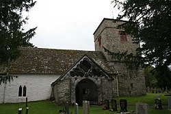
 Church of St Cewydd | |
| Location | |
| Grid reference: | SO080476 |
| Location: | 52°7’0"N, 3°21’0"W |
| Data | |
| Population: | 614 |
| Post town: | Builth Wells |
| Postcode: | LD2 |
| Local Government | |
| Council: | Powys |
| Parliamentary constituency: |
Brecon & Radnorshire |
Aberedw is a village and parish in southern Radnorshire near the border with Brecknockshire.
The ruins of the mediæval Aberedw Castle are nearby.
It is also the site of Llywelyn ap Gruffudd's death, although it is commonly thought that this occurred in Cilmery, where his men were finally defeated.
The church of St Cewydd is a grade II* listed building. [1]
References
- ↑ "Church of St Cewydd, Aberedw". British Listed Buildings. http://www.britishlistedbuildings.co.uk/wa-8803-church-of-st-cewydd-aberedw. Retrieved 15 December 2013.
Outside links
This Radnorshire article is a stub: help to improve Wikishire by building it up.