Ibthorpe: Difference between revisions
Jump to navigation
Jump to search
Created page with "{{Infobox town |name=Ibthorpe |county=Hampshire |picture=Ibthorpe House - geograph.org.uk - 1067367.jpg |picture caption=Ibthorpe House |os grid ref=SU377537 |latitude=51.2816..." |
No edit summary |
||
| Line 14: | Line 14: | ||
|constituency=North West Hampshire | |constituency=North West Hampshire | ||
}} | }} | ||
'''Ibthorpe''' is a village in the north of [[Hampshire]], immediately north of [[Hurstbourne Tarrant]] on the [[Bourne Rivulet]]. | '''Ibthorpe''' is a village in the north of [[Hampshire]], immediately north-west of and essentially attached to [[Hurstbourne Tarrant]] on the [[Bourne Rivulet|River Swift]]. | ||
The name of Ibthorpe is believed to be from the Old English ''Inbban þorp'', meaning means, "Ibba's village". | The name of Ibthorpe is believed to be from the Old English ''Inbban þorp'', meaning means, "Ibba's village". | ||
Revision as of 13:09, 12 October 2022
| Ibthorpe | |
| Hampshire | |
|---|---|
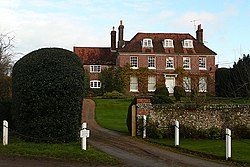
 Ibthorpe House | |
| Location | |
| Grid reference: | SU377537 |
| Location: | 51°16’54"N, 1°27’35"W |
| Data | |
| Post town: | Andover |
| Postcode: | SP11 |
| Local Government | |
| Council: | Test Valley |
| Parliamentary constituency: |
North West Hampshire |
Ibthorpe is a village in the north of Hampshire, immediately north-west of and essentially attached to Hurstbourne Tarrant on the River Swift.
The name of Ibthorpe is believed to be from the Old English Inbban þorp, meaning means, "Ibba's village".
Most houses in the hamlet stand around a central horseshoe-shaped road, with some extending toward neighbouring Hurstbourne Tarrant.
Pictures
| ("Wikimedia Commons" has material about Ibthorpe) |
-
Thatched barn
-
Weathervane
-
Road to Frenches Farm
-
Ibthorpe radio tower


