Bush, Cornwall: Difference between revisions
Jump to navigation
Jump to search
Created page with "{{Infobox town |name=Bush |county=Cornwall |picture=Stratton and Bude, Poughill Mill, Bush - geograph.org.uk - 105068.jpg |picture caption=Poughill Mill, Bush |os grid ref=SS2..." |
No edit summary |
||
| Line 15: | Line 15: | ||
|constituency= | |constituency= | ||
}} | }} | ||
'''Bush''' is a hamlet in the very north-east of [[Cornwall]], on the A39 a mile north of [[Stratton]] and two miles north-east of [[Bude]]. The village of [[Poughill]] is just to the west of Bush, and that village's watermill, Poughill Mill, is at Bush, on the | '''Bush''' is a hamlet in the very north-east of [[Cornwall]], on the A39 a mile north of [[Stratton, Cornwall|Stratton]] and two miles north-east of [[Bude]]. The village of [[Poughill]] is just to the west of Bush, and that village's watermill, Poughill Mill, is at Bush, on the River Strat. | ||
==References== | ==References== | ||
Latest revision as of 22:22, 25 September 2016
| Bush | |
| Cornwall | |
|---|---|
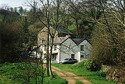
 Poughill Mill, Bush | |
| Location | |
| Grid reference: | SS233076 |
| Location: | 50°50’29"N, 4°30’39"W |
| Data | |
| Post town: | Bude |
| Postcode: | EX23 |
| Local Government | |
| Council: | Cornwall |
Bush is a hamlet in the very north-east of Cornwall, on the A39 a mile north of Stratton and two miles north-east of Bude. The village of Poughill is just to the west of Bush, and that village's watermill, Poughill Mill, is at Bush, on the River Strat.
References

This Cornwall article is a stub: help to improve Wikishire by building it up.