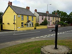
Scleddau: Difference between revisions
Jump to navigation
Jump to search
Created page with "{{Infobox town | name=Scleddau | county = Pembrokeshire | picture= Scleddau - geograph.org.uk - 208661.jpg | picture caption= | os grid ref= SM93SW88 | latitude=51.967814 | l..." |
No edit summary |
||
| Line 15: | Line 15: | ||
| dialling code= 01348 | | dialling code= 01348 | ||
}} | }} | ||
'''Scleddau''' is a village | '''Scleddau''' is a village in [[Pembrokeshire]], located two miles south of [[Fishguard]] on the A40 road.<ref>[http://www.e-gymraeg.com/enwaucymru/chwilio.aspx/Scleddau Bangor University Placenames Unit (Canolfan Bedwyr);] accessed 9 May 2014</ref> The village gives its name to a civil community, covering the ancient parishes of [[Jordanston]], [[Llanstinan]], [[Llanfair-Nant-y-Gof]], [[Manorowen]] and part of Fishguard. In 2011 the population of Scleddau was 971.<ref>[http://wales.gov.uk/statistics-and-research/census-population/?lang=en Welsh Government website; 2011 Census Returns and stats;] accessed 9 May 2014</ref> | ||
The [[River Cleddau]] which lends its name to the village flows under the main road. Castell Hendre-Wen and the Round Barrow on Jordanson Hill are both Scheduled prehistoric Monuments dating back to the early Iron Age.<ref>[http://www.coflein.gov.uk/en/site/305195/details/CASTELL+HENDRE-WEN%3B+CASTELL+BYTHEG/ Coflein (Cadw) website;] accessed 10 May 2014.</ref><ref>[http://www.pembrokeshire.gov.uk/content.asp?id=13116&nav=107,1174&parent_directory_id=&criteria=bro&language=&mode=property&uprn=10090687558 Pembrokeshire County Council website;] accessed 10 May 2014.</ref> A mile south-east of Scleddau | The [[River Cleddau]] which lends its name to the village flows under the main road. Castell Hendre-Wen and the Round Barrow on Jordanson Hill are both Scheduled prehistoric Monuments dating back to the early Iron Age.<ref>[http://www.coflein.gov.uk/en/site/305195/details/CASTELL+HENDRE-WEN%3B+CASTELL+BYTHEG/ Coflein (Cadw) website;] accessed 10 May 2014.</ref><ref>[http://www.pembrokeshire.gov.uk/content.asp?id=13116&nav=107,1174&parent_directory_id=&criteria=bro&language=&mode=property&uprn=10090687558 Pembrokeshire County Council website;] accessed 10 May 2014.</ref> A mile south-east of Scleddau is the Grade II-listed Church of St Justinian, in the village of [[Trecwn]]. | ||
==References== | ==References== | ||
{{reflist}} | {{reflist}} | ||
{{stub}} | {{stub}} | ||
Latest revision as of 14:36, 17 May 2021
| Scleddau | |
| Pembrokeshire | |
|---|---|

| |
| Location | |
| Grid reference: | SM93SW88 |
| Location: | 51°58’4"N, 4°59’36"W |
| Data | |
| Population: | 971 (2001) |
| Post town: | Fishguard |
| Postcode: | SA65 |
| Dialling code: | 01348 |
| Local Government | |
| Council: | Pembrokeshire |
| Parliamentary constituency: |
Preseli Pembrokeshire |
Scleddau is a village in Pembrokeshire, located two miles south of Fishguard on the A40 road.[1] The village gives its name to a civil community, covering the ancient parishes of Jordanston, Llanstinan, Llanfair-Nant-y-Gof, Manorowen and part of Fishguard. In 2011 the population of Scleddau was 971.[2]
The River Cleddau which lends its name to the village flows under the main road. Castell Hendre-Wen and the Round Barrow on Jordanson Hill are both Scheduled prehistoric Monuments dating back to the early Iron Age.[3][4] A mile south-east of Scleddau is the Grade II-listed Church of St Justinian, in the village of Trecwn.
References
- ↑ Bangor University Placenames Unit (Canolfan Bedwyr); accessed 9 May 2014
- ↑ Welsh Government website; 2011 Census Returns and stats; accessed 9 May 2014
- ↑ Coflein (Cadw) website; accessed 10 May 2014.
- ↑ Pembrokeshire County Council website; accessed 10 May 2014.

This Pembrokeshire article is a stub: help to improve Wikishire by building it up.