Shetland: Difference between revisions
mNo edit summary |
mNo edit summary |
||
| Line 1: | Line 1: | ||
{{Infobox county | {{Infobox county | ||
|name=Shetland | |name=Shetland | ||
|map image= | |map image=Shetland Brit Isles Sect 1.svg | ||
|flag=Flag of Shetland.svg | |flag=Flag of Shetland.svg | ||
|picture=Klippen bei Eshaness3 5845.JPG | |picture=Klippen bei Eshaness3 5845.JPG | ||
| Line 13: | Line 13: | ||
Shetland contains the United Kingdom's northernmost point, the rock of Out Stack, north of [[Muckle Flugga]], Britain's northernmost island. | Shetland contains the United Kingdom's northernmost point, the rock of Out Stack, north of [[Muckle Flugga]], Britain's northernmost island. | ||
Due to the islands' high latitude the Northern Lights (''aurora borealis'') can sometimes be seen in the sky | Due to the islands' high latitude the Northern Lights (''aurora borealis'') can sometimes be seen in the sky on clear winter nights, while in summer there is almost perpetual daylight, known locally as the "simmer dim". | ||
The islands' remote, northern location has laid them open to different cultural influences. Early in the | The islands' remote, northern location has laid them open to different cultural influences. Early in the Viking Period Shetland was settled by Norsemen, and whether they drove its previous population out or absorbed them, Shetland became a Norse land and almost all of Shetland's place-names are derived from the Norse language. In the days of King Harold Fairhair of Norway, Shetland became part of the new Earldom of Orkney, and it remained under the Norwegian crown until 1468, when it was given to King James III King of Scots as a pledge for a dowry, which pledge was not redeemed. | ||
The Norn language had died out by the nineteenth century, replaced by Scots and English, though its influence remains strong in dialect words. | The Norn language had died out by the nineteenth century, replaced by Scots and English, though its influence remains strong in dialect words. | ||
Revision as of 22:22, 16 January 2015
| Shetland United Kingdom | |

| |
|---|---|

| |
| Flag | |
| Með Lögum Skal Land Byggja (With laws shall this land be built) | |

| |
| [Interactive map] | |
| Area: | 551 square miles |
| Population: | 21,988 |
| County town: | Lerwick |
| County flower: | Shetland mouse-ear [1] |
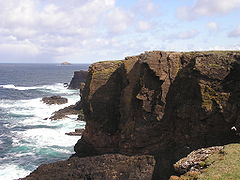
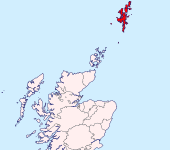
The County of Shetland or Zetland is the northernmost shire of the United Kingdom. It consists of a group of many mountainous islands in the seas to the north of Great Britain.
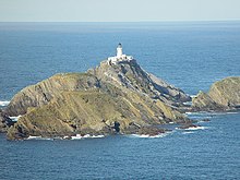
Shetland contains the United Kingdom's northernmost point, the rock of Out Stack, north of Muckle Flugga, Britain's northernmost island.
Due to the islands' high latitude the Northern Lights (aurora borealis) can sometimes be seen in the sky on clear winter nights, while in summer there is almost perpetual daylight, known locally as the "simmer dim".
The islands' remote, northern location has laid them open to different cultural influences. Early in the Viking Period Shetland was settled by Norsemen, and whether they drove its previous population out or absorbed them, Shetland became a Norse land and almost all of Shetland's place-names are derived from the Norse language. In the days of King Harold Fairhair of Norway, Shetland became part of the new Earldom of Orkney, and it remained under the Norwegian crown until 1468, when it was given to King James III King of Scots as a pledge for a dowry, which pledge was not redeemed.
The Norn language had died out by the nineteenth century, replaced by Scots and English, though its influence remains strong in dialect words.
The islands
Shetland has some 100 islands, of which only 15 are inhabited.
The main island of the group is Mainland, which contains the county's capital, Lerwick, its former capital, Scalloway, and most of the substantial settlements. Mainland has an area of 373 square miles, making it the fifth-largest island of the British Isles.

The inhabited islands in the main group are:
- Mainland
- Bressay (opposite Lerwick)
- Burra
- Fetlar
- Muckle Roe
- Papa Stour
- Trondra
- Vaila
- Unst (Britain's northernmost inhabited island)
- Whalsay
- Yell
Further out lie:
- Foula to the south-west,
- Fair Isle to the south, halfway to Orkney
- Housay
- Bruray in the Out Skerries to the east.
Parishes
Shetland is divided into twelve civil parishes.
The oil industry
In the early 1970s, oil and gas were found off Shetland. The East Shetland Basin is one of the largest petroleum sedimentary basins in Europe and the oil extracted there is sent to the terminal at Sullom Voe (Norse: Solheimavagr). Sullom Voe terminal opened in 1978 and is the largest oil export harbour in the United Kingdom, with a volume of 25 million tons per year.
Income from oil and related economies has reduced emigration and vastly improved infrastructure throughout Shetland. Sheep farming also plays a big part in Shetland today as does fishing.
Timeline
| Year | Event |
|---|---|
| 3400 BC | First sign of settlement |
| 43 & 77 AD | Roman authors Pomponius Mela and Pliny the Elder refer to the seven islands they call Haemodae and Acmodae respectively, assumed to be Shetland.[1] |
| 297 AD | Roman sources mention the Picts |
| 875 | Harald Hårfagre took control of the islands |
| 1195 | Harald Maddadsson lost the earldom of Shetland and the islands are put directly under the Norwegian king Sverre Sigurdsson |
| 1379 | The Scottish earl Henry Sinclair took control of Orkney on behalf of the Norwegian king Håkon VI Magnusson |
| 1469 | Christian I gave Shetland to the Scottish king James III as a pledge for a dowry |
| 1700–1760 | Smallpox hit the islands |
| 18th century | Norn language gradually dies out |
| 1707 | Shetland became part of the Kingdom of Great Britain. The German merchants lost their trading rights in Shetland |
| 1708 | Capital moved from Scalloway to Lerwick |
| 1861 | 32,000 inhabitants |
| 1940 | Shetland bus established by the Special Operations Executive |
| 1961 | 17,814 inhabitants |
| 1969 | Shetland marks 500 years under both Norwegian and Scottish rule |
| 1978 | Oil terminal in Sullom Voe opened |
| 2001 | 21,990 inhabitants |
| 2005 | Lord Lyon King of Arms, the heraldic authority of Scotland, approved the blue and white flag of Shetland as an official flag |
| 2009 | 22,210 inhabitants |
County flag

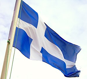
Roy Grönneberg designed a flag for Shetland in 1969 in cooperation with Bill Adams, to mark the 500 year anniversary of the transfer of Shetland from Norway to Scotland.[2]
The rationale of the design was to illustrate the Shetland had been a part of Norway for 500 years and a part of Scotland for 500 years. The colours are identical to those of the St Andrew flag of Scotland, but shaped in the Nordic cross. (It is the same design Icelandic republicans used in the early 20th century, known in Iceland as Hvítbláinn, the white-blue.)
In 1975 when the new Shetland Islands Council came into being, Grönneberg wanted his proposed flag to become the official flag of Shetland, but was unsuccessful. Finally in 2005 the Lord Lyon King of Arms approved the flag as the official flag of Shetland.
Notable places and buildings
- Cunningsburgh
- Clickimin Broch
- Fort Charlotte
- Jarlshof archaeological site
- Lerwick Town Hall
- Mavis Grind
- Mousa Broch
- Muness Castle the most northerly castle in the United Kingdom
- Old Scatness archaeological site
- Scalloway Castle
- St Ninian's Isle
- Sullom Voe oil terminal
- Sumburgh Head
- Skaw the most northerly settlement in the United Kingdom
Outside links
- Shetlopedia - The Online Shetland Encyclopedia that anyone can edit
- Shetlink - Shetland's Online Community
- Shetland.org
- Visit.Shetland.org - Official website for tourism in Shetland
- Shetland Dialect
- Shetland Scenes
- Virtual Tour of Shetland
- Tom Weir on the Shetland Language
- ShetlandDictionary.com - Online Shetland Dictionary
- Shetland Foraminifera – Deep Sea Fauna: Foraminifera of the Faroe-Shetland Channel - an image gallery and description of 56 specimens
References
- ↑ Breeze, David J. "The ancient geography of Scotland" in Ballin Smith and Banks (2002) pp. 12–13.
- ↑ Flags of the Worlds page on the flag of Shetland
| Counties of the United Kingdom |
|---|
|
Aberdeen • Anglesey • Angus • Antrim • Argyll • Armagh • Ayr • Banff • Bedford • Berks • Berwick • Brecknock • Buckingham • Bute • Caernarfon • Caithness • Cambridge • Cardigan • Carmarthen • Chester • Clackmannan • Cornwall • Cromarty • Cumberland • Denbigh • Derby • Devon • Dorset • Down • Dumfries • Dunbarton • Durham • East Lothian • Essex • Fermanagh • Fife • Flint • Glamorgan • Gloucester • Hants • Hereford • Hertford • Huntingdon • Inverness • Kent • Kincardine • Kinross • Kirkcudbright • Lanark • Lancaster • Leicester • Lincoln • Londonderry • Merioneth • Middlesex • Midlothian • Monmouth • Montgomery • Moray • Nairn • Norfolk • Northampton • Northumberland • Nottingham • Orkney • Oxford • Peebles • Pembroke • Perth • Radnor • Renfrew • Ross • Roxburgh • Rutland • Selkirk • Shetland • Salop • Somerset • Stafford • Stirling • Suffolk • Surrey • Sussex • Sutherland • Tyrone • Warwick • West Lothian • Westmorland • Wigtown • Wilts • Worcester • York |