Kemble: Difference between revisions
Created page with 'right|thumb|250px|Kemble '''Kemble''' is a village in Wiltshire. It lies four miles from [[Cirencester…' |
No edit summary |
||
| (2 intermediate revisions by one other user not shown) | |||
| Line 1: | Line 1: | ||
{{Infobox town | |||
'''Kemble''' is a village in [[Wiltshire]]. It lies four miles from [[Cirencester]] and is the settlement closest to [[Thames Head]], the source of the [[River Thames]]. | |county=Wilts | ||
|picture=All Saints Church Kemble spire - geograph.org.uk - 132486.jpg | |||
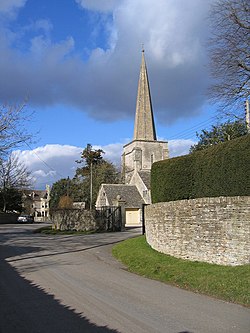
|picture captiob=All Saints, Kemble | |||
|population=1,036 | |||
|census year=2011<ref name="population_2011">{{cite web |title=Area: Kemble (Parish): Key Figures for 2011 Census: Key Statistics |url=http://www.neighbourhood.statistics.gov.uk/dissemination/LeadKeyFigures.do?a=7&b=11125097&c=Kemble&d=16&e=62&g=6427126&i=1001x1003x1032x1004&m=0&r=1&s=1423923890990&enc=1 |website=Neighbourhood Statisdtics |publisher=Office for National Statistics |accessdate=28 July 2018}}</ref> | |||
|LG district=Cotswold | |||
|constituency=Cotswold | |||
|post town=Cirencester | |||
|postcode=GL7 | |||
|dialling code=01285 | |||
|latitude=51.683333 | |||
|longitude=-2.016667 | |||
|os grid ref=ST987973 | |||
}} | |||
'''Kemble''' is a village and parish in the [[Malmesbury Hundred]] of [[Wiltshire]]. It lies four miles from [[Cirencester]] in [[Gloucestershire]] and is the settlement closest to [[Thames Head]], the source of the [[River Thames]]. | |||
Kemble Church is part of the Thameshead benefice, comprising the communities of Kemble, Ewen, Poole Keynes, [[Somerford Keynes]], and Shorncote.<ref>[http://www.kemble.co.uk Kemble Church information page]</ref> The benefice since 2001 also includes Coates, Rodmarton, Sapperton, Tarlton and Frampton Mansel.<ref>[http://www.somerfordkeynes.org.uk/churchindex.htm Somerford Keynes church information page]</ref>. | Kemble Church is part of the Thameshead benefice, comprising the communities of Kemble, Ewen, Poole Keynes, [[Somerford Keynes]], and Shorncote.<ref>[http://www.kemble.co.uk Kemble Church information page]</ref> The benefice since 2001 also includes Coates, Rodmarton, Sapperton, Tarlton and Frampton Mansel.<ref>[http://www.somerfordkeynes.org.uk/churchindex.htm Somerford Keynes church information page]</ref>. | ||
| Line 10: | Line 24: | ||
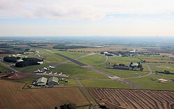
[[File:cotswold airport at kemble from helicopter arp.jpg|right|thumb|250px|Cotswold Airport looking east]] | [[File:cotswold airport at kemble from helicopter arp.jpg|right|thumb|250px|Cotswold Airport looking east]] | ||
==Flying== | ==Flying== | ||
[[Cotswold Airport]] (previously known as Kemble Airport) is on the edge of the village. The airfield is used by light industry, by flying clubs and by private aircraft owners, for events including two annual air displays, and for scrapping and storage of airliners. Delta Jets rebuild, maintain and fly historic jet aircraft, particularly Hawker Hunters. The Bristol Aero collection has a museum at the airfield. | [[Cotswold Airport]] (previously known as Kemble Airport) is on the edge of the village (and directly on the county border). The airfield is used by light industry, by flying clubs and by private aircraft owners, for events including two annual air displays, and for scrapping and storage of airliners. Delta Jets rebuild, maintain and fly historic jet aircraft, particularly Hawker Hunters. The Bristol Aero collection has a museum at the airfield. | ||
[[Aston Down]] airfield, three miles to the northwest, formerly belonged to the RAF but is now used for gliding by the Cotswold Gliding Club. | [[Aston Down]] airfield, three miles to the northwest, formerly belonged to the RAF but is now used for gliding by the Cotswold Gliding Club. | ||
| Line 21: | Line 35: | ||
*[http://www.kemble.me/ Kemble Community website ] | *[http://www.kemble.me/ Kemble Community website ] | ||
*[http://www.kemble.co.uk/ Kemble village website ] | *[http://www.kemble.co.uk/ Kemble village website ] | ||
*[http://www.kemble-airfield.co.uk/ Kemble Airfield (renamed Cotswold Airport in 2009)] | *[http://www.kemble-airfield.co.uk/ Kemble Airfield (renamed Cotswold Airport in 2009)] | ||
[[Category:Towns and villages in Wiltshire]] | [[Category:Towns and villages in Wiltshire]] | ||
Latest revision as of 11:53, 10 January 2020
| Kemble | |
| Wiltshire | |
|---|---|

| |
| Location | |
| Grid reference: | ST987973 |
| Location: | 51°40’60"N, 2°1’0"W |
| Data | |
| Population: | 1,036 (2011[1]) |
| Post town: | Cirencester |
| Postcode: | GL7 |
| Dialling code: | 01285 |
| Local Government | |
| Council: | Cotswold |
| Parliamentary constituency: |
Cotswold |
Kemble is a village and parish in the Malmesbury Hundred of Wiltshire. It lies four miles from Cirencester in Gloucestershire and is the settlement closest to Thames Head, the source of the River Thames.
Kemble Church is part of the Thameshead benefice, comprising the communities of Kemble, Ewen, Poole Keynes, Somerford Keynes, and Shorncote.[2] The benefice since 2001 also includes Coates, Rodmarton, Sapperton, Tarlton and Frampton Mansel.[3].
Kemble was once an important railway junction. The Golden Valley Line from Swindon to Cheltenham passes through the village, and branch lines from Cirencester and Tetbury met here. Today, although the branch lines were dismantled in the 1960s, Kemble railway station is still important for passengers travelling from Cirencester. The station has a direct link to Swindon and London Paddington in one direction, and to Gloucester and Cheltenham in the other.
There is but one pub, "The Tavern", is ext to the station. A combined Post Office and local store provides most essentials.

Flying
Cotswold Airport (previously known as Kemble Airport) is on the edge of the village (and directly on the county border). The airfield is used by light industry, by flying clubs and by private aircraft owners, for events including two annual air displays, and for scrapping and storage of airliners. Delta Jets rebuild, maintain and fly historic jet aircraft, particularly Hawker Hunters. The Bristol Aero collection has a museum at the airfield.
Aston Down airfield, three miles to the northwest, formerly belonged to the RAF but is now used for gliding by the Cotswold Gliding Club.
References
- ↑ "Area: Kemble (Parish): Key Figures for 2011 Census: Key Statistics". Office for National Statistics. http://www.neighbourhood.statistics.gov.uk/dissemination/LeadKeyFigures.do?a=7&b=11125097&c=Kemble&d=16&e=62&g=6427126&i=1001x1003x1032x1004&m=0&r=1&s=1423923890990&enc=1. Retrieved 28 July 2018.
- ↑ Kemble Church information page
- ↑ Somerford Keynes church information page
Outside links
| ("Wikimedia Commons" has material about Kemble) |
