St Neots: Difference between revisions
m Pictures |
mNo edit summary |
||
| Line 28: | Line 28: | ||
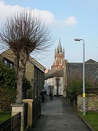
[[File:StNeotsTown-12.jpg|left|200px|Church Walk]] | [[File:StNeotsTown-12.jpg|left|200px|Church Walk]] | ||
==Outside links== | |||
{{commons|St Neots, Cambridgeshire}} | |||
*[http://www.stneots-tc.gov.uk/ Town Council] | |||
*[http://www.st-neots.co.uk/ St Neots Community Pages] (residents' forums) | |||
*[http://groups.projectforum.com/171/274 Churches] | |||
*[http://www.stneotsmuseum.org.uk/ Museum] | |||
*[http://www.thepriorycentre.com/ The Priory Centre] | |||
*[http://www.livedepartureboards.co.uk/ldb/summary.aspx?T=SNO&R=1 Train times] | |||
*[http://www.stneotscitizen.com/ St Neots Citizen, a local spoof news site] | |||
==References== | ==References== | ||
{{reflist}} | {{reflist}} | ||
*[http://www.huntsdc.gov.uk/Community+and+People/Neighbourhood-village/Towns+and+Villages/St+Neots.htm] | |||
* [http://www.huntsdc.gov.uk/Community+and+People/Neighbourhood-village/Towns+and+Villages/St+Neots.htm | |||
Latest revision as of 13:06, 18 April 2018
| St Neots | |
| Huntingdonshire | |
|---|---|
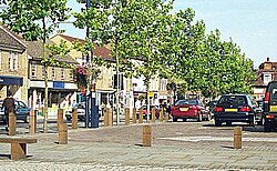
 Market square, St Neots | |
| Location | |
| Grid reference: | TL185605 |
| Location: | 52°13’48"N, 0°15’36"W |
| Data | |
| Population: | 26,356 (2001) |
| Post town: | St. Neots |
| Postcode: | PE19 |
| Dialling code: | 01480 |
| Local Government | |
| Council: | Huntingdonshire |
| Parliamentary constituency: |
Huntingdon |
St Neots is the largest town in the south of Huntingdonshire. It lies on the banks of the River Great Ouse, where the Great Ouse enters Huntingdonshire. Across the river are Eaton Socon and Eaton Ford, Bedfordshire villages. The Great North Road runs to Eaton Socon, and so St Neots has prospered from that connection. Today St Neots is a thriving market town and commuter town and continues to grow rapidly due to a huge demand for modern housing.
The town has a broad, green meadow beside the bridge, between the town and the river, the Riverside Fields. The fields are popular for recreation and serve as a flood buffer area; the field is under water at times of flood, protecting the town.
The main town was formerly Eynesbury, a name kept by the southern part of the town, but in the Anglo-Saxon period a priory was founded to the north of Eynesbury, where the bridge crosses the Great Ouse. The priory was named after the Cornish monk St Neot whose bones were stolen from the village of St Neot on Bodmin Moor and concealed in the priory, and the town which grew around the priory took the same name, and it appears in the Anglo-Saxon Chronicle as Sancte Neod. Eynesbury now forms part of St Neots. The Normans rebuilt the priory near the river and the town of St Neots grew up against its southern wall. The pilgrim trade brought prosperity for the town that grew around the priory, and it was granted a market charter in 1130.
In the 18th and 19th centuries, the town enjoyed further prosperity through corn milling, brewing, stagecoaches and railways.
The priory is remembered in today's town by the Priory Centre, a municipal arts and functions venue.

Outside links
| ("Wikimedia Commons" has material about St Neots) |
- Town Council
- St Neots Community Pages (residents' forums)
- Churches
- Museum
- The Priory Centre
- Train times
- St Neots Citizen, a local spoof news site
