Crumlin, County Dublin: Difference between revisions
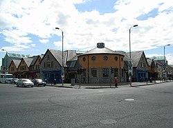
Created page with "{{Infobox town |name=Crumlin |irish=Cromghlinn |county=Dublin |picture=The Submarine Bar, Crumlin - geograph.org.uk - 447187.jpg |picture caption=The Submarine Bar, Crumlin |o..." |
No edit summary |
||
| (One intermediate revision by one other user not shown) | |||
| Line 5: | Line 5: | ||
|picture=The Submarine Bar, Crumlin - geograph.org.uk - 447187.jpg | |picture=The Submarine Bar, Crumlin - geograph.org.uk - 447187.jpg | ||
|picture caption=The Submarine Bar, Crumlin | |picture caption=The Submarine Bar, Crumlin | ||
|os grid ref= | |os grid ref=O114317 | ||
|latitude=53.324 | |latitude=53.324 | ||
|longitude=-6.329 | |longitude=-6.329 | ||
|population= | |population= | ||
|census year= | |census year= | ||
|post town= | |post town=Dublin | ||
|postcode= | |postcode=D12 | ||
|dialling code= | |dialling code=01 | ||
|LG district= | |LG district=Dublin | ||
|constituency= | |constituency= | ||
}} | }} | ||
'''Crumlin''' is a | '''Crumlin''' is a southside suburb of [[Dublin]], in [[County Dublin]]. A densely populated residential area, with some industry, it is also the site of Ireland's largest children's hospital. | ||
The name of the village is from the Irish ''Cromghlinn'', meaning 'Crooked Glen'. It gets its name from the crooked valley known as Lansdowne Valley. The valley was formed by glacial erosion in the distant past and is now bisected by the [[River Camac]]. The valley is situated in front of Drimnagh and is largely made up of good-quality houses with plentiful recreational parkland. | The name of the village is from the Irish ''Cromghlinn'', meaning 'Crooked Glen'. It gets its name from the crooked valley known as Lansdowne Valley. The valley was formed by glacial erosion in the distant past and is now bisected by the [[River Camac]]. The valley is situated in front of Drimnagh and is largely made up of good-quality houses with plentiful recreational parkland. | ||
| Line 27: | Line 27: | ||
Crumlin, along with [[Saggart]], [[Newcastle, County Dublin|Newcastle]], Lyons and Esker ([[Lucan]]) was constituted a royal manor by King John sometime before the end of his reign in 1216. The English noble families of the time had strong links with Ireland, particularly in Leinster. For example, William Fitz John of Harptree was a lord of some significance in Somerset and likely to have served in Ireland under King John. At the beginning of the reign of King Henry III, Fitz John acquired the custody of the lands of William de Carew and held the royal manor of Crumlin, although he did not establish family roots in Ireland.<ref>Ireland and Britain, 1170-1450 - Robin Frame 1998. {{ISBN|0826445446}}, 9780826445445</ref><ref>The History of the County of Dublin. John D'Alton. Hodges and Smith, 1838. Digitised by Google 22 Jun 2006</ref> | Crumlin, along with [[Saggart]], [[Newcastle, County Dublin|Newcastle]], Lyons and Esker ([[Lucan]]) was constituted a royal manor by King John sometime before the end of his reign in 1216. The English noble families of the time had strong links with Ireland, particularly in Leinster. For example, William Fitz John of Harptree was a lord of some significance in Somerset and likely to have served in Ireland under King John. At the beginning of the reign of King Henry III, Fitz John acquired the custody of the lands of William de Carew and held the royal manor of Crumlin, although he did not establish family roots in Ireland.<ref>Ireland and Britain, 1170-1450 - Robin Frame 1998. {{ISBN|0826445446}}, 9780826445445</ref><ref>The History of the County of Dublin. John D'Alton. Hodges and Smith, 1838. Digitised by Google 22 Jun 2006</ref> | ||
As the church was the nucleus of life on the manor in mediæval times, we may with confidence place the centre of Crumlin's mediæval settlement in the area of Crumlin Village. This has been confirmed by recent archaeological excavations in the area of St Mary' | As the church was the nucleus of life on the manor in mediæval times, we may with confidence place the centre of Crumlin's mediæval settlement in the area of Crumlin Village. This has been confirmed by recent archaeological excavations in the area of St Mary's and the site of the former motte and earthworks on which the new St Mary's Church was built. | ||
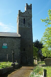
[[File:St. Mary's Church, Crumlin Village, Dublin - South East View.jpg|right|thumb|200px|St | [[File:St. Mary's Church, Crumlin Village, Dublin - South East View.jpg|right|thumb|200px|St Mary's Church, Crumlin Village]] | ||
==About the village== | ==About the village== | ||
Crumlin is home to Our Lady's Children's Hospital, Crumlin, the largest children's hospital in the country. A number of roads are named after some of Ulster's towns and various Irish towns associated with pagan or religious sites/towns. There's a statue of the Ulster warrior Cúchulainn situated opposite St | Crumlin is home to Our Lady's Children's Hospital, Crumlin, the largest children's hospital in the country. A number of roads are named after some of Ulster's towns and various Irish towns associated with pagan or religious sites/towns. There's a statue of the Ulster warrior Cúchulainn situated opposite St Mary's Church at the junction with Bunting Road. The statue is for Oisín, he was a Kildare man who played hurling in the Crumlin area. Cúchulainn, his father, was from the Cooley mountains around Louth, South Armagh where the Cooley Road in Drimnagh gets its name and is described as a partially wooded landscape, the crooked glen being one of its main features. Today this valley can be seen behind Drimnagh Castle. | ||
==Sport== | ==Sport== | ||
| Line 41: | Line 41: | ||
*Rugby: Guinness Rugby Football Club, based at the Iveagh Grounds | *Rugby: Guinness Rugby Football Club, based at the Iveagh Grounds | ||
*Football: | *Football: | ||
** | **Crumlin United F.C. | ||
** | **St James's Gate F.C. | ||
**Lourdes Celtic F.C. | **Lourdes Celtic F.C. | ||
*Boxing: Crumlin Boxing Club | *Boxing: Crumlin Boxing Club | ||
Latest revision as of 15:55, 18 February 2021
| Crumlin Irish: Cromghlinn | |
| County Dublin | |
|---|---|
 The Submarine Bar, Crumlin | |
| Location | |
| Grid reference: | O114317 |
| Location: | 53°19’26"N, 6°19’44"W |
| Data | |
| Post town: | Dublin |
| Postcode: | D12 |
| Dialling code: | 01 |
| Local Government | |
| Council: | Dublin |
Crumlin is a southside suburb of Dublin, in County Dublin. A densely populated residential area, with some industry, it is also the site of Ireland's largest children's hospital.
The name of the village is from the Irish Cromghlinn, meaning 'Crooked Glen'. It gets its name from the crooked valley known as Lansdowne Valley. The valley was formed by glacial erosion in the distant past and is now bisected by the River Camac. The valley is situated in front of Drimnagh and is largely made up of good-quality houses with plentiful recreational parkland.
History
During the Middle Ages, Dublin was surrounded by manorial settlements comprising church, graveyard, manor house, motte and bailey, farms and cottages. These settlements grew into a network of villages around Dublin creating stability and continuity of location. Crumlin Village developed as an Anglo-Norman settlement soon after the Norman Conquest in 1170, (although the circular configuration of the old graveyard of Saint Mary's in the village suggests pre-Norman associations), and has survived through the centuries to become the village of today. The Old Saint Mary's Church stands on the site of a 12th-century church of the same dedication, and a succession of churches occupied the site down through the centuries to the present day.
In 1193, King John (the then Prince of Moreton) gave the Crumlin church to form one prebend in the collegiate church of St Patrick. When the main body of the present old church was rebuilt in 1817, the old tower of a much earlier origin was preserved.
Crumlin, along with Saggart, Newcastle, Lyons and Esker (Lucan) was constituted a royal manor by King John sometime before the end of his reign in 1216. The English noble families of the time had strong links with Ireland, particularly in Leinster. For example, William Fitz John of Harptree was a lord of some significance in Somerset and likely to have served in Ireland under King John. At the beginning of the reign of King Henry III, Fitz John acquired the custody of the lands of William de Carew and held the royal manor of Crumlin, although he did not establish family roots in Ireland.[1][2]
As the church was the nucleus of life on the manor in mediæval times, we may with confidence place the centre of Crumlin's mediæval settlement in the area of Crumlin Village. This has been confirmed by recent archaeological excavations in the area of St Mary's and the site of the former motte and earthworks on which the new St Mary's Church was built.

About the village
Crumlin is home to Our Lady's Children's Hospital, Crumlin, the largest children's hospital in the country. A number of roads are named after some of Ulster's towns and various Irish towns associated with pagan or religious sites/towns. There's a statue of the Ulster warrior Cúchulainn situated opposite St Mary's Church at the junction with Bunting Road. The statue is for Oisín, he was a Kildare man who played hurling in the Crumlin area. Cúchulainn, his father, was from the Cooley mountains around Louth, South Armagh where the Cooley Road in Drimnagh gets its name and is described as a partially wooded landscape, the crooked glen being one of its main features. Today this valley can be seen behind Drimnagh Castle.
Sport
- Gaelic athletics:
- Crumlin GAA (based in Pearse Park, with clubrooms in O'Toole Park)
- Kevin's GAA (based in Dolphin Park)
- Templeogue Synge Street GAA (based in Dolphin Park, with clubrooms in Bushy Park)
- St James Gaels (who play at the Iveagh Grounds
- Rugby: Guinness Rugby Football Club, based at the Iveagh Grounds
- Football:
- Crumlin United F.C.
- St James's Gate F.C.
- Lourdes Celtic F.C.
- Boxing: Crumlin Boxing Club
- Wrestling: Wrestling Academy, based on Sundrive Road