Cheeks Hill: Difference between revisions
Jump to navigation
Jump to search
Created page with '{{Infobox hill |name=Cheeks Hill |county 1=Staffordshire |county 2=Derbyshire |picture=Cheeks Hill - geograph.org.uk - 175759.jpg |picture caption=Cheeks Hill summit from the Sta…' |
No edit summary |
||
| Line 8: | Line 8: | ||
|range=Staffordshire Moorlands | |range=Staffordshire Moorlands | ||
|os grid ref= SK02616990 | |os grid ref= SK02616990 | ||
|latitude=53.2261 | |||
|longitude=-1.9623 | |||
}} | }} | ||
'''Cheeks Hill''' is a hill near [[Buxton]], standing on the border between [[Derbyshire]] and [[Staffordshire]]. The border here forms an acute angle, with Derbyshire all around and Staffordshire in the point; Cheeks Hill stands at the apex. | '''Cheeks Hill''' is a hill near [[Buxton]], standing on the border between [[Derbyshire]] and [[Staffordshire]]. The border here forms an acute angle, with Derbyshire all around and Staffordshire in the point; Cheeks Hill stands at the apex. | ||
| Line 16: | Line 18: | ||
==Profile== | ==Profile== | ||
At the summit there is a dry stone wall marking the border between Staffordshire and Derbyshire, on the Staffordshire side there is a | At the summit there is a dry stone wall marking the border between Staffordshire and Derbyshire, on the Staffordshire side there is a disused quarry and shaft, On the Derbyshire side is Dane Head which is the start of the [[River Dane]], nearby is Three Shires Head and Cheeks Hill is the most northern point in Staffordshire. | ||
[[Category:County tops]] | [[Category:County tops]] | ||
[[Category:Extreme points of Staffordshire]] | |||
Latest revision as of 19:00, 10 March 2018
| Cheeks Hill | |||
| Staffordshire, Derbyshire | |||
|---|---|---|---|
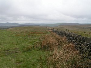
 Cheeks Hill summit from the Staffordshire side | |||
| Range: | Staffordshire Moorlands | ||
| Summit: | 1,705 feet SK02616990 53°13’34"N, 1°57’44"W | ||
Cheeks Hill is a hill near Buxton, standing on the border between Derbyshire and Staffordshire. The border here forms an acute angle, with Derbyshire all around and Staffordshire in the point; Cheeks Hill stands at the apex.
Cheeks Hill, on the very border, is the highest point in Staffordshire, reaching 1,705 feet high.
The hill is part of the Axe Edge Moor and lies close to the Cat and Fiddle Road.
Profile
At the summit there is a dry stone wall marking the border between Staffordshire and Derbyshire, on the Staffordshire side there is a disused quarry and shaft, On the Derbyshire side is Dane Head which is the start of the River Dane, nearby is Three Shires Head and Cheeks Hill is the most northern point in Staffordshire.