Stoer Head: Difference between revisions
No edit summary |
|||
| (One intermediate revision by the same user not shown) | |||
| Line 1: | Line 1: | ||
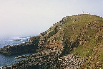
[[File:Stoer Head - geograph.org.uk - 877199.jpg|right|thumb|350px|Stour Head]] | [[File:Stoer Head - geograph.org.uk - 877199.jpg|right|thumb|350px|Stour Head]] | ||
{{county|Sutherland}} | {{county|Sutherland}} | ||
'''Stoer Head''' is a headland north of [[Lochinver]] and the township of [[Stoer]] in [[Sutherland]], marking the northern entrance to [[the Minch]]. A lighthouse, the [[ | '''Stoer Head''' is a headland north of [[Lochinver]] and the township of [[Stoer]] in [[Sutherland]], marking the northern entrance to [[the Minch]]. A lighthouse, the [[Stoer Head Lighthouse]], stands on the point. | ||
==Geography== | ==Geography== | ||
The peninsula is about four miles long and two miles wide. It has a number of scattered, small settlements including Culkein, Balchladich and Achnacarnin. The lighthouse is at the end of a track three miles long which branches off the B869 Lochinver to Unapool road.<ref name=walkbrit>[http://www.walkingbritain.co.uk/walks/walks/walk_b/1266/ The Old Man of Stoer and the Point of Stoer] - Walking Britain</ref> Further North up the coast are the [[Old Man of Stoer]] and the | The peninsula is about four miles long and two miles wide. It has a number of scattered, small settlements including Culkein, Balchladich and Achnacarnin. The lighthouse is at the end of a track three miles long which branches off the B869 Lochinver to Unapool road.<ref name=walkbrit>[http://www.walkingbritain.co.uk/walks/walks/walk_b/1266/ The Old Man of Stoer and the Point of Stoer] - Walking Britain</ref> Further North up the coast are the [[Old Man of Stoer]] and the Point of Stoer, which can easily be reached from the lighthouse on foot.<ref name=walkbrit/><ref>[http://www.british-coast-maps.com/map-stoer.jpg Map of Stoer]: British Coast Maps</ref> | ||
The '''Point of Stoer''' ({{map|NC021354}}; {{wmap|58.263417|-5.375159|zoom=14}}) is the jutting headland at the very north of the peninsula, two miles north of the headland bearing the Stoer Head Lighthouse. | |||
Around 10,000 visitors visit the lighthouse each year (necessitating the construction of a public toilet in 2013).<ref>'[https://www.bbc.co.uk/news/uk-scotland-highlands-islands-23601269 New toilet at remote Sutherland Stoer Head Lighthouse]' - BBC News 16 August 2013</ref> The two keepers' cottages are now holiday homes.<ref>{{canmore|4524|Stoer Head Lighthouse}}</ref> | Around 10,000 visitors visit the lighthouse each year (necessitating the construction of a public toilet in 2013).<ref>'[https://www.bbc.co.uk/news/uk-scotland-highlands-islands-23601269 New toilet at remote Sutherland Stoer Head Lighthouse]' - BBC News 16 August 2013</ref> The two keepers' cottages are now holiday homes.<ref>{{canmore|4524|Stoer Head Lighthouse}}</ref> | ||
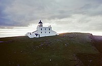
[[File:Stoer Head Lighthouse at Sunset from East 1990.jpg|right|thumb|200px|The Stour Head Lighthouse]] | [[File:Stoer Head Lighthouse at Sunset from East 1990.jpg|right|thumb|200px|The Stour Head Lighthouse]] | ||
==Location== | ==Location== | ||
*Streetmap: {{map|NC019330}} | *Streetmap: {{map|NC019330}} | ||
Latest revision as of 23:35, 23 February 2019

Stoer Head is a headland north of Lochinver and the township of Stoer in Sutherland, marking the northern entrance to the Minch. A lighthouse, the Stoer Head Lighthouse, stands on the point.
Geography
The peninsula is about four miles long and two miles wide. It has a number of scattered, small settlements including Culkein, Balchladich and Achnacarnin. The lighthouse is at the end of a track three miles long which branches off the B869 Lochinver to Unapool road.[1] Further North up the coast are the Old Man of Stoer and the Point of Stoer, which can easily be reached from the lighthouse on foot.[1][2]
The Point of Stoer (NC021354; 58°15’48"N, 5°22’31"W) is the jutting headland at the very north of the peninsula, two miles north of the headland bearing the Stoer Head Lighthouse.
Around 10,000 visitors visit the lighthouse each year (necessitating the construction of a public toilet in 2013).[3] The two keepers' cottages are now holiday homes.[4]

Location
- Streetmap: NC019330
- Location map: 58°14’29"N, 5°22’31"W
Outside links
| ("Wikimedia Commons" has material about Stoer Head Lighthouse) |
- Stoer Peninsula on Undiscovered Scotland
- Stoer Head Lighthouse - Northern Lighthouse Board
- Stoer Head Lighthouse Accommodation
- ↑ 1.0 1.1 The Old Man of Stoer and the Point of Stoer - Walking Britain
- ↑ Map of Stoer: British Coast Maps
- ↑ 'New toilet at remote Sutherland Stoer Head Lighthouse' - BBC News 16 August 2013
- ↑ CANMORE (RCAHMS) record of Stoer Head Lighthouse
