Opsay: Difference between revisions
Jump to navigation
Jump to search
Created page with "{{Infobox island |name=Opsay |gaelic=Opasaigh |county=Inverness-shire |group=Sound of Harris |picture= |picture caption= |os grid ref=NF981761 |latitude=57.673225 |longitude=-..." |
No edit summary |
||
| Line 9: | Line 9: | ||
|latitude=57.673225 | |latitude=57.673225 | ||
|longitude=-7.064209 | |longitude=-7.064209 | ||
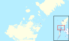
|map= | |map=Opsay, Sound of Harris, OH.svg | ||
|highest point=40 feet | |highest point=40 feet | ||
|population=0 | |population=0 | ||
Latest revision as of 07:55, 4 March 2017
| Opsay Gaelic: Opasaigh | |
| Location | |
| Location: | 57°40’24"N, 7°3’51"W |
| Grid reference: | NF981761 |
| Highest point: | 40 feet |
| Data | |
| Population: | 0 |
Opsay is a small, uninhabited island in the Sound of Harris; barely an island but a low, rocky place most of which is beneath the water at high tide.
The isle lies just off the north coast of North Uist, and between Opsay and North Uist lie the more substantial small isles of Sursay, Tahay, Bhacasaigh and Hermetray.
As with the other islands of the sound, Opsay belongs to Inverness-shire.
| The islands of the Sound of Harris, Inverness-shire | ||
|---|---|---|
| Harris |
Berneray • Boreray • Keallasay More • Ensay • Gilsay • Groay • Hermetray • Killegray • Opsay • Pabbay • Sgarabhaigh • Shillay • Stromay • Sursay • Tahay • |
North Uist
|
