Lochgoilhead: Difference between revisions
m clean up, typos fixed: a isolated → an isolated |
No edit summary |
||
| Line 7: | Line 7: | ||
|latitude=56.171078 | |latitude=56.171078 | ||
|longitude=-4.9019629 | |longitude=-4.9019629 | ||
|post town=Cairndow | |||
|postcode=PA24 | |postcode=PA24 | ||
|LG district=Argyll and Bute | |LG district=Argyll and Bute | ||
| Line 17: | Line 18: | ||
The village stands at the head of [[Loch Goil]], hence its name, at the place where the Goil river, which rises on nearby [[Ben Donich]] and [[Beinn an Lochain]], flows into the loch. | The village stands at the head of [[Loch Goil]], hence its name, at the place where the Goil river, which rises on nearby [[Ben Donich]] and [[Beinn an Lochain]], flows into the loch. | ||
Lochgoilhead is surrounded by mountains rising as high as 3,000 feet and is within of the [[Arrochar Alps]]. The village itself sits underneath the south side mountains of [[Glen Croe]], where [[Beinn an Lochain]], [[Stob an Eas]], [[Ben Donich]], and [[The Brack]] stand. | Lochgoilhead is surrounded by mountains rising as high as 3,000 feet and is within of the [[Arrochar Alps]]. The village itself sits underneath the south-side mountains of [[Glen Croe]], where [[Beinn an Lochain]], [[Stob an Eas]], [[Ben Donich]], and [[The Brack]] stand. Lochgoilhead stands in the [[Loch Lomond and the Trossachs]] National Park. The surrounding area has a mountainous, coastal, and forestry landscape. | ||
There is no major route through Lochgoilhead, leaving it isolated on the B839 local road, for the main trunk route is further north, to get around the head of [[Loch Fyne]]. The only roads to and from the village are the B839 going north up the | There is no major route through Lochgoilhead, leaving it isolated on the B839 local road, for the main trunk route is further north, to get around the head of [[Loch Fyne]]. The only roads to and from the village are the B839 going north up the Goil's wee glen and a dead-end lane down the west shore of the loch, and no side roads as the mountains are forbidding. A few miles north of Lochgoilhead the B839 has a junction leading north-east to the A83 at [[Rest and Be Thankful]] in [[Glen Croe]] or north-west to the A815 down Loch Fyne. | ||
BBC News correspondent Alan Johnston, who was kidnapped in The Gaza Strip by Palestinian militants, spent many years in Lochgoilhead in his youth. Which was an isolated place or a more exciting place to live he has not said. | BBC News correspondent Alan Johnston, who was kidnapped in The Gaza Strip by Palestinian militants, spent many years in Lochgoilhead in his youth. Which was an isolated place or a more exciting place to live he has not said. | ||
| Line 31: | Line 32: | ||
==References== | ==References== | ||
{{Reflist}} | {{Reflist}} | ||
Latest revision as of 12:14, 30 June 2017
| Lochgoilhead | |
| Argyllshire | |
|---|---|
 Lochgoilhead | |
| Location | |
| Grid reference: | NN19930140 |
| Location: | 56°10’16"N, 4°54’7"W |
| Data | |
| Post town: | Cairndow |
| Postcode: | PA24 |
| Local Government | |
| Council: | Argyll and Bute |
Lochgoilhead is a small village of some 300-400 people in Argyllshire.
The main employment spheres include tourism, agriculture (mainly sheep farming), and forestry. There are two outdoor education centres in the village, The Lochgoilhead National Activity Centre and Ardroy Outdoor Education Centre. Tourism more than doubles the village population during the summer months. Two single-track roads both lead in and out of the village. It has a Post Office, village store, a medical and dental practice, two hotels, two pubs, and an inn.
Location
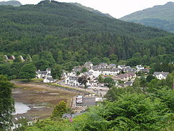
The village stands at the head of Loch Goil, hence its name, at the place where the Goil river, which rises on nearby Ben Donich and Beinn an Lochain, flows into the loch.
Lochgoilhead is surrounded by mountains rising as high as 3,000 feet and is within of the Arrochar Alps. The village itself sits underneath the south-side mountains of Glen Croe, where Beinn an Lochain, Stob an Eas, Ben Donich, and The Brack stand. Lochgoilhead stands in the Loch Lomond and the Trossachs National Park. The surrounding area has a mountainous, coastal, and forestry landscape.
There is no major route through Lochgoilhead, leaving it isolated on the B839 local road, for the main trunk route is further north, to get around the head of Loch Fyne. The only roads to and from the village are the B839 going north up the Goil's wee glen and a dead-end lane down the west shore of the loch, and no side roads as the mountains are forbidding. A few miles north of Lochgoilhead the B839 has a junction leading north-east to the A83 at Rest and Be Thankful in Glen Croe or north-west to the A815 down Loch Fyne.
BBC News correspondent Alan Johnston, who was kidnapped in The Gaza Strip by Palestinian militants, spent many years in Lochgoilhead in his youth. Which was an isolated place or a more exciting place to live he has not said.
On film
The highlands above the village were used for the scene in the 1963 James Bond film From Russia with Love, in which Bond (played by Sean Connery) eliminated two villains in a helicopter by firing gunshots at them.[1] The 1985 film Restless Natives also used Lochgoilhead to film a chase scene, as well as some roads just outside the village.
Outside links
References
- ↑ From Russia with Love at the Internet Movie Database (1963)