Drummaul: Difference between revisions
Jump to navigation
Jump to search
Created page with "'''Drummaul''' is a townland and parish in County Antrim. It is situated in the barony of Toome Upper and contains the town of Randalstown.<ref name="KC">{{cit..." |
|||
| Line 61: | Line 61: | ||
==Drummaul Townland== | ==Drummaul Townland== | ||
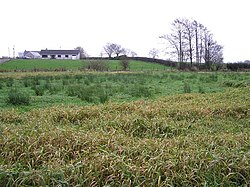
[[File:Drummaul Townland - geograph.org.uk - 636989.jpg|thumb|right|250px|Drummaul townland in 2007]] | [[File:Drummaul Townland - geograph.org.uk - 636989.jpg|thumb|right|250px|Drummaul townland in 2007]] | ||
The townland | The townland covers an area of 339 acres to the south-west of the intersection of the B18 and B93 roads.<ref>{{cite web | title=Drummaul| work=IreAtlas Townland Database| url=http://www.seanruad.com | accessdate=13 May 2013}}</ref> | ||
The population of the townland decreased during the 19th century:<ref>{{cite web | title=Census of Ireland 1851| work=Enhanced Parliamentary Papers on Ireland| url=http://eppi.dippam.ac.uk/documents/13130/eppi_pages/336613 | accessdate=13 May 2013}}</ref><ref>{{cite web | title=Census of Ireland 1891| work=Enhanced Parliamentary Papers on Ireland| url=http://eppi.dippam.ac.uk/documents/18814/eppi_pages/504643 | accessdate=13 May 2013}}</ref> | The population of the townland decreased during the 19th century:<ref>{{cite web | title=Census of Ireland 1851| work=Enhanced Parliamentary Papers on Ireland| url=http://eppi.dippam.ac.uk/documents/13130/eppi_pages/336613 | accessdate=13 May 2013}}</ref><ref>{{cite web | title=Census of Ireland 1891| work=Enhanced Parliamentary Papers on Ireland| url=http://eppi.dippam.ac.uk/documents/18814/eppi_pages/504643 | accessdate=13 May 2013}}</ref> | ||
Latest revision as of 10:55, 8 November 2015
Drummaul is a townland and parish in County Antrim. It is situated in the barony of Toome Upper and contains the town of Randalstown.[1]
The name derives from the Irish Druim Mail meaning "Mal's ridge".[2]
Drummaul Parish
The parish is bounded by the civil parishes of Duneane, Portglenone, Ahoghill and Braid, and to the south by Lough Neagh.[1] It contains the following townlands:[3][4]
- Aughaboy
- Aghaloughan
- Andraid
- Artresnahan
- Aughalish
- Ballealy South
- Ballydunmaul
- Ballygrooby
- Ballylurgan
- Ballymacilroy
- Ballynacraigy
- Ballynaleney
- Ballytresna
- Barnish
- Caddy
- Clare
- Cloghogue
- Clonboy
- Clonkeen
- Coolsythe
- Cormorant Rock
- Craigmore
- Creagh
- Downkillybegs
- Drumanaway
- Drummaul
- Drumsough
- Farlough
- Feehogue
- Gortagharn
- Groggan
- Kilknock
- Killyfad
- Leitrim
- Lenagh
- Lisnagreggan
- Lurgan West
- Magherabeg
- Magheralane
- Mount Shalgus
- Muckleramer
- Portlee
- Procklis
- Randalstown
- Shane's Castle Park
- Sharvogues
- Skady Tower
- Tamlaght
- Tannaghmore
- Terrygowan
Drummaul Townland

The townland covers an area of 339 acres to the south-west of the intersection of the B18 and B93 roads.[5]
The population of the townland decreased during the 19th century:[6][7]
| Year | 1841 | 1851 | 1861 | 1871 | 1881 | 1891 |
|---|---|---|---|---|---|---|
| Population | 177 | 172 | 170 | 142 | 136 | 112 |
| Houses | 29 | 26 | 27 | 30 | 29 | 24 |
References
- ↑ 1.0 1.1 "Drummaul". KiwiCelts. http://family.kiwicelts.com/21_Places_and_History/Place_Antrim.html#Drummaul. Retrieved 13 May 2013.
- ↑ "Drummaul". Place Names NI. http://www.placenamesni.org/historicforms.php?getPnameId=5189. Retrieved 13 May 2013.
- ↑ "Parish of Drummaul". Public Record Office NI. http://applications.proni.gov.uk/geogindx/parishes/par117.htm. Retrieved 13 May 2013.
- ↑ "Parish of Drummaul". Ulster Ancestors. http://www.ballynagarrick.net/ulsterancestors/Drumm. Retrieved 13 May 2013.
- ↑ "Drummaul". IreAtlas Townland Database. http://www.seanruad.com. Retrieved 13 May 2013.
- ↑ "Census of Ireland 1851". Enhanced Parliamentary Papers on Ireland. http://eppi.dippam.ac.uk/documents/13130/eppi_pages/336613. Retrieved 13 May 2013.
- ↑ "Census of Ireland 1891". Enhanced Parliamentary Papers on Ireland. http://eppi.dippam.ac.uk/documents/18814/eppi_pages/504643. Retrieved 13 May 2013.