Derrykeighan: Difference between revisions
Jump to navigation
Jump to search
Created page with "{{Infobox town |county=Antrim |irish=Doire Chaocháin |picture=The old Church, Derrykeighan, County Antrim - geograph.org.uk - 114845.jpg |picture caption=The Old Church, D..." |
No edit summary |
||
| (One intermediate revision by the same user not shown) | |||
| Line 6: | Line 6: | ||
|postcode=BT53 | |postcode=BT53 | ||
|dialling code=028 | |dialling code=028 | ||
|constituency=North Antrim | |constituency=North Antrim | ||
|townland=yes | |||
}} | }} | ||
'''Derrykeighan''' is a hamlet, parish and townland (of 161 acres) in [[County Antrim]], four miles north of [[Ballymoney]]. It is situated in the barony of [[Dunluce Lower]].<ref name=Ire>{{cite web|title=Derrykeighan|url=http://www.thecore.com/seanruad/|website=IreAtlas Townlands Database|accessdate=9 May 2015}}</ref> Its name is from the Gaelic ''Doire Chaocháin'' meaning "Caochán’s oak-wood"<ref name=Pla>{{cite web|title=Derrykeighan|url=http://www.placenamesni.org/resultdetails.php?entry=15866|website=Place Names NI|accessdate=9 May 2015}}</ref> The parish covers includes the village of [[Dervock]].<ref name=Ire/> | '''Derrykeighan''' is a hamlet, parish and townland (of 161 acres) in [[County Antrim]], four miles north of [[Ballymoney]]. It is situated in the barony of [[Dunluce Lower]].<ref name=Ire>{{cite web|title=Derrykeighan|url=http://www.thecore.com/seanruad/|website=IreAtlas Townlands Database|accessdate=9 May 2015}}</ref> Its name is from the Gaelic ''Doire Chaocháin'' meaning "Caochán’s oak-wood"<ref name=Pla>{{cite web|title=Derrykeighan|url=http://www.placenamesni.org/resultdetails.php?entry=15866|website=Place Names NI|accessdate=9 May 2015}}</ref> The parish covers includes the village of [[Dervock]].<ref name=Ire/> | ||
| Line 15: | Line 16: | ||
===Townlands=== | ===Townlands=== | ||
The civil parish contains the following townlands:<ref name=Ire/> | The civil parish contains the following townlands:<ref name=Ire/> | ||
{{ | {{townlandliststart}} | ||
*[[Aghancrossy]] | *[[Aghancrossy]] | ||
*[[Ballydivity]] | *[[Ballydivity]] | ||
| Line 53: | Line 54: | ||
*[[Stroan Upper]] | *[[Stroan Upper]] | ||
*[[Tullybane]] | *[[Tullybane]] | ||
{{ | {{townlandlistend}} | ||
==References== | ==References== | ||
{{Reflist}} | {{Reflist}} | ||
{{Commonscat|Derrykeighan}} | {{Commonscat|Derrykeighan}} | ||
Latest revision as of 23:05, 7 November 2015
| Derrykeighan Irish: Doire Chaocháin | |
| County Antrim | |
|---|---|
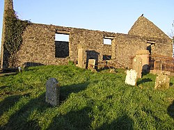
 The Old Church, Derrykeighan, in 2006 | |
| Location | |
| Data | |
| Postcode: | BT53 |
| Dialling code: | 028 |
| Local Government | |
| Parliamentary constituency: |
North Antrim |
Derrykeighan is a hamlet, parish and townland (of 161 acres) in County Antrim, four miles north of Ballymoney. It is situated in the barony of Dunluce Lower.[1] Its name is from the Gaelic Doire Chaocháin meaning "Caochán’s oak-wood"[2] The parish covers includes the village of Dervock.[1]
History
The site of the mediæval parish church, and also of an early church, is marked by the ruins of a later church in Derrykeighan.[2]
Townlands
The civil parish contains the following townlands:[1]
- Aghancrossy
- Ballydivity
- Ballyhibistock Lower
- Ballyhibistock Upper
- Ballynafeigh
- Ballynarry Upper
- Ballyratahan
- Ballyratahan
- Beerhill
- Bellisle
- Carnaff
- Carncoggy
- Carncullagh Lower
- Carncullagh Middle
- Carncullagh Upper
- Carnfeogue
- Carracloghy
- Chathamhall
- Coole
- Deepstown
- Derrykeighan
- Dervock
- Drumcrottagh
- Glebe
- Gracehill
- Islandahoe
- Knockanboy
- Knockavallan
- Lisconnan
- Lisnabraugh
- Livery Lower
- Livery Upper
- Mostragee
- Mullaghduff
- Stroan Lower
- Stroan Upper
- Tullybane
References
- ↑ 1.0 1.1 1.2 "Derrykeighan". http://www.thecore.com/seanruad/. Retrieved 9 May 2015.
- ↑ 2.0 2.1 "Derrykeighan". http://www.placenamesni.org/resultdetails.php?entry=15866. Retrieved 9 May 2015.
| ("Wikimedia Commons" has material about Derrykeighan) |
