Beulah, Brecknockshire: Difference between revisions
Jump to navigation
Jump to search
Created page with "{{Infobox town | county=Brecknockshire | name=Beulah | picture=Eglwys Oen Duw at Beulah, Powys (geograph 2343878).jpg | picture caption=The 'Lamb of God' | population= | os g..." |
No edit summary |
||
| Line 12: | Line 12: | ||
| post town=Llanwrtyd Wells | | post town=Llanwrtyd Wells | ||
| postcode=LD5 | | postcode=LD5 | ||
| dialling code= | | dialling code=01591 | ||
}} | }} | ||
'''Beulah''' is a village in northern [[Brecknockshire]], lying on the [[River Cammarch]], 3¾ miles upstream of [[Llanwrtyd Wells]]. The village sits astride the main A483 road about eight miles south west of [[Builth Wells]] and 154 miles from [[London]]. | '''Beulah''' is a village in northern [[Brecknockshire]], lying on the [[River Cammarch]], 3¾ miles upstream of [[Llanwrtyd Wells]]. The village sits astride the main A483 road about eight miles south west of [[Builth Wells]] and 154 miles from [[London]]. | ||
Latest revision as of 15:21, 27 October 2014
| Beulah | |
| Brecknockshire | |
|---|---|
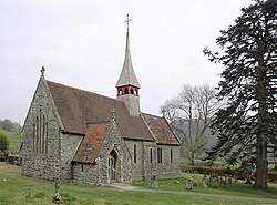
 The 'Lamb of God' | |
| Location | |
| Grid reference: | SN95SW32 |
| Location: | 52°8’55"N, 3°34’44"W |
| Data | |
| Post town: | Llanwrtyd Wells |
| Postcode: | LD5 |
| Dialling code: | 01591 |
| Local Government | |
| Council: | Powys |
| Parliamentary constituency: |
Brecon & Radnorshire |
Beulah is a village in northern Brecknockshire, lying on the River Cammarch, 3¾ miles upstream of Llanwrtyd Wells. The village sits astride the main A483 road about eight miles south west of Builth Wells and 154 miles from London.
It benefits from both a pub and service station with attached shop. The parish church Eglwys Oen Duw ("Lamb of God"), built in 1867, can be found amile to the north east of the village.
References
| ("Wikimedia Commons" has material about Powys Beulah, Brecknockshire) |

This Brecknockshire article is a stub: help to improve Wikishire by building it up.
