Black Mountain, Black Mountains: Difference between revisions
Created page with '{{Infobox hill |name=Black Mountain |welsh=Twyn Llech |county 1=Herefordshire |county 2=Brecknockshire |range=Black Mountains |picture= Black Mountain Top.jpg |picture caption=Th…' |
No edit summary |
||
| Line 9: | Line 9: | ||
|height=2,306 feet | |height=2,306 feet | ||
|os grid ref=SO255350 | |os grid ref=SO255350 | ||
|latitude=52.008412 | |||
|longitude=-3.086804 | |||
}} | }} | ||
'''Black Mountain''' is the highest peak on the [[Hatterrall Ridge]], the easternmost outlier of the [[Black Mountains]]. Black Mountain is the [[county top]] of [[Herefordshire]] - that county's highest point - though the ridge and Black Mountain mark the boundary between [[Brecknockshire]] to the west and [[Herefordshire]] to the east and consequently the mountain summit is in both. | '''Black Mountain''' is the highest peak on the [[Hatterrall Ridge]], the easternmost outlier of the [[Black Mountains]]. Black Mountain is the [[county top]] of [[Herefordshire]] - that county's highest point - though the ridge and Black Mountain mark the boundary between [[Brecknockshire]] to the west and [[Herefordshire]] to the east and consequently the mountain summit is in both. | ||
Latest revision as of 13:26, 6 September 2017
| Black Mountain | |||
| Herefordshire, Brecknockshire | |||
|---|---|---|---|
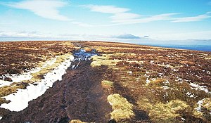
 The summit of Black Mountain | |||
| Range: | Black Mountains | ||
| Summit: | 2,306 feet SO255350 52°-0’30"N, 3°5’12"W | ||
Black Mountain is the highest peak on the Hatterrall Ridge, the easternmost outlier of the Black Mountains. Black Mountain is the county top of Herefordshire - that county's highest point - though the ridge and Black Mountain mark the boundary between Brecknockshire to the west and Herefordshire to the east and consequently the mountain summit is in both.
This Black Mountain should not be confused with the Black Mountain range about 30 miles to the west, nor with the Black Hill about a mile east.
The Offa's Dyke Path passes along the ridge, more or less from south to north, while a steeper path leads to the summit from near the former youth hostel in the Vale of Ewyas below to the west.
Summit
The summit is unmarked and, because of the very shallow gradients along the summit ridge, virtually impossible to determine in situ.
This summit is the highest ground in England south of Great Whernside in the Yorkshire Dales,[1] even though higher neighbours are very close by, in Wales.