Difference between revisions of "Girsby Bridge"
From Wikishire
(Created page with "{{Infobox bridge |name=Girsby Bridge |county 1=Durham |county 2=Yorkshire |picture=Girsby bridge - geograph.org.uk - 2231444.jpg |picture caption=Girsby Bridge |os grid ref=NZ...") |
(→References) |
||
| Line 26: | Line 26: | ||
==References== | ==References== | ||
{{reflist}} | {{reflist}} | ||
| − | *{{bridgesonthetyne | + | *{{bridgesonthetyne}} |
{{Tees bridges}} | {{Tees bridges}} | ||
Latest revision as of 21:02, 3 September 2024
| Girsby Bridge | |
| County Durham, Yorkshire | |
|---|---|
 Girsby Bridge | |
| Location | |
| Crossing: | River Tees |
| Location | |
| Grid reference: | NZ35190826 |
| Location: | 54°28’7"N, 1°27’31"W |
| Structure | |
| History | |
| Built 1870 | |
| Information | |
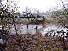
Girsby Bridge is a footbridge bridge which crosses the River Tees, from County Durham on the north bank to the North Riding of Yorkshire on the south, by the Yorkshire village of Girsby.
The bridge was provided by Theophania Blackett, widow of Sir William, of Sockburn Hall across the river to give access to the church. She was then granted exclusive use of the then existing nearby bridge at Sockburn.
References
- Girsby Bridge: Bridges on the Tyne
| Bridges and crossings on the River Tees | ||||||
|---|---|---|---|---|---|---|
| Tees Bridge | Low Hail Bridge | Neasham Hall Bridge | Girsby Bridge | Fishlocks Bridge | Over Dinsdale Bridge | Yarm Viaduct |