Ainsty: Difference between revisions
No edit summary |
|||
| (3 intermediate revisions by the same user not shown) | |||
| Line 1: | Line 1: | ||
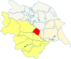
[[File:The Ainsty - Yorkshire.svg|thumb|250px|The Ainsty shown within the West Riding and Yorkshire]] | |||
The '''Ainsty''' or '''Ainsty of York''' is a [[wapentake]] in the [[West Riding of Yorkshire|West Riding]] of [[Yorkshire]]. It is bounded by [[Claro]] to the north-west; by [[Barkston Ash Wapentake|Barkston Ash]] to the south; by [[Ouse and Derwent]] in the East Riding to the east; by the city of York within the walls to the north-east; and by [[Bulmer]] in the North Riding to the north-east. Including those suburbs of York in the West Riding, the the Ainsty had a population of 80,689 in 2011. | The '''Ainsty''' or '''Ainsty of York''' is a [[wapentake]] in the [[West Riding of Yorkshire|West Riding]] of [[Yorkshire]]. It is bounded by [[Claro]] to the north-west; by [[Barkston Ash Wapentake|Barkston Ash]] to the south; by [[Ouse and Derwent]] in the East Riding to the east; by the city of York within the walls to the north-east; and by [[Bulmer]] in the North Riding to the north-east. Including those suburbs of York in the West Riding, the the Ainsty had a population of 80,689 in 2011. | ||
| Line 12: | Line 13: | ||
{{div col|3}} | {{div col|3}} | ||
*[[Acaster Malbis]] (part)<sup>*</sup> | *[[Acaster Malbis]] (part)<sup>*</sup> | ||
*[[Acomb]] | *[[Acomb, Yorkshire|Acomb]] | ||
*[[Askham Bryan]] | *[[Askham Bryan]] | ||
*[[Askham Richard]] | *[[Askham Richard]] | ||
*[[Bilbrough]] | *[[Bilbrough]] | ||
*[[Bilton]] | *[[Bilton-in-Ainsty]] | ||
*[[Bishopthorpe]] | *[[Bishopthorpe]] | ||
*[[Bolton Percy]] | *[[Bolton Percy]] | ||
*[[Healaugh]] | *[[Healaugh, West Riding|Healaugh]] | ||
*[[Kirk Hammerton]] (Wilstrop)<sup>†</sup> | *[[Kirk Hammerton]] (Wilstrop)<sup>†</sup> | ||
*[[Long Marston, Yorkshire|Long Marston]] | *[[Long Marston, Yorkshire|Long Marston]] | ||
| Line 26: | Line 27: | ||
*[[Rufforth]] | *[[Rufforth]] | ||
*[[St Mary Bishophill]] | *[[St Mary Bishophill]] | ||
*[[Stillingfleet]] (Acaster Selby)<sup>‡</sup> | *[[Stillingfleet]] ([[Acaster Selby]])<sup>‡</sup> | ||
*[[Tadcaster]] (Catterton, Oxton and Tadcaster East)<sup>§</sup> | *[[Tadcaster]] (Catterton, Oxton and Tadcaster East)<sup>§</sup> | ||
*[[Thorpe Arch]] | *[[Thorpe Arch]] | ||
| Line 40: | Line 41: | ||
{{reflist}} | {{reflist}} | ||
{{Yorkshire wapentakes}} | {{Yorkshire wapentakes|riding=West}} | ||
Latest revision as of 10:10, 7 September 2021

The Ainsty or Ainsty of York is a wapentake in the West Riding of Yorkshire. It is bounded by Claro to the north-west; by Barkston Ash to the south; by Ouse and Derwent in the East Riding to the east; by the city of York within the walls to the north-east; and by Bulmer in the North Riding to the north-east. Including those suburbs of York in the West Riding, the the Ainsty had a population of 80,689 in 2011.
History
The Ainsty is first recorded in the Domesday Book of 1086 in the form Ainestig. It was named from Ainsty Cliff at Bilbrough,[1] presumably the original meeting place of the wapentake. Ainsty Cliff was itself named from a small narrow path which led from Steeton Farm over Ainsty Cliff to Bilbrough. The word Ainsty is from Old English ān stiga, meaning "one-man path" or "narrow path", which became einstigi in Old Norse.[2]
The city of York later claimed jurisdiction over the area under a royal charter of King John granted in the early 13th century. The validity of this charter was a matter of dispute between the city and the Crown, eventually leading to the imprisonment of the mayor in 1280 when it was proved that a clause in the document had been altered.[3] The bailiffs of the city were subsequently able to resume jurisdiction of the wapentake, although it was not formally included in the city when it was created a county corporate in 1396.[3]
In 1449 the Ainsty was annexed to York, with the sheriffs of the city assuming authority. The city, which was said to be "in decay", was granted the "privileges and franchises" of the Ainsty to improve its financial position. In 1463 the mayor and aldermen were made justices of the peace with the commission of oyer and terminer.
Parishes
The wapentake includes the ancient parishes of:
- Acaster Malbis (part)*
- Acomb
- Askham Bryan
- Askham Richard
- Bilbrough
- Bilton-in-Ainsty
- Bishopthorpe
- Bolton Percy
- Healaugh
- Kirk Hammerton (Wilstrop)†
- Long Marston
- Moor Monkton
- Nether Poppleton
- Rufforth
- St Mary Bishophill
- Stillingfleet (Acaster Selby)‡
- Tadcaster (Catterton, Oxton and Tadcaster East)§
- Thorpe Arch
- Walton
- Wighill
*: Partly in the Ouse and Derwent wapentake (E. R.)
†: Remainder in Claro wapentake.
‡: Mostly in Ouse and Derwent (E. R.)
§: Remainder in Barkston Ash wapentake.
References
- ↑ Smith, A.H. (1961). The Place-names of the West Riding of Yorkshire. 4. Cambridge University Press. p. 216.
- ↑ Smith, A.H. (1961). The Place-names of the West Riding of Yorkshire. 4. Cambridge University Press. p. 235.
- ↑ 3.0 3.1 Tillott, P.M., ed (1961). "The boundaries of the City". Victoria County History. A History of the County of York: the City of York. British History Online. pp. 311–321. http://www.british-history.ac.uk/report.aspx?compid=36369. Retrieved 29 July 2010.
|
East Riding: Buckrose • Dickering • Harthill • Holderness • Howdenshire • Ouse and Derwent • North Riding: Allertonshire • Birdforth • Bulmer • East Gilling • Hallikeld • Hang East • Hang West • Langbaurgh • Pickering Lythe • Ryedale • West Gilling • Whitby Strand • West Riding: Agbrigg and Morley (Agbrigg, Morley) • Ainsty • Barkston Ash • Claro • Osgoldcross • Skyrack • Staincliffe and Ewcross (Staincliffe, Ewcross) • Staincross • Strafforth and Tickhill |
