Llanbister: Difference between revisions
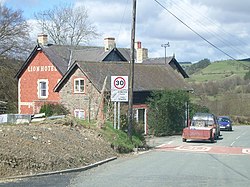
Created page with "{{Infobox town | county=Radnorshire | name=Llanbister | picture=The_Lion_Hotel,_Llanbister_-_geograph.org.uk_-_154298.jpg | picture caption=The Lion Hotel | population=382 | ..." |
m →Facilities: clean up, replaced: medieval → mediæval |
||
| Line 27: | Line 27: | ||
There is a Victorian pub and bed and breakfast hotel (The Lion Hotel) in the village and a caravan and camping site to the north west of the village, near the former police station. | There is a Victorian pub and bed and breakfast hotel (The Lion Hotel) in the village and a caravan and camping site to the north west of the village, near the former police station. | ||
There is an area of common land to the east of the village, named Llanbister Common. In July 1991 an unlicensed free music festival was held there, which was not well received by the local population, so in summer 1992 manure was spread on the land to make a repeat less likely.<ref>[http://www.independent.co.uk/news/uk/roads-closed-as-police-seal-off-hippie-festival-farmers-condemn-the-invasion-of-a-farm-in-a-remote-part-of-wales-by-an-estimated-4000-travellers-1535848.html Roads closed as police seal off hippie festival], Stephen Ward, The Independent, Monday 27 July 1992</ref> There is evidence of potentially | There is an area of common land to the east of the village, named Llanbister Common. In July 1991 an unlicensed free music festival was held there, which was not well received by the local population, so in summer 1992 manure was spread on the land to make a repeat less likely.<ref>[http://www.independent.co.uk/news/uk/roads-closed-as-police-seal-off-hippie-festival-farmers-condemn-the-invasion-of-a-farm-in-a-remote-part-of-wales-by-an-estimated-4000-travellers-1535848.html Roads closed as police seal off hippie festival], Stephen Ward, The Independent, Monday 27 July 1992</ref> There is evidence of potentially mediæval ridge and furrow cultivation on Llanbister Common.<ref>[http://www.coflein.gov.uk/en/site/511970/details/CEFN+LLANBISTER,+CULTIVATION+RIDGES/ Cefn Llanbister, Cultivation Ridges], National Monuments Record of Wales online database, retrieved 12 March 2014</ref> | ||
==Churches== | ==Churches== | ||
Latest revision as of 10:24, 30 January 2021
| Llanbister | |
| Radnorshire | |
|---|---|
 The Lion Hotel | |
| Location | |
| Grid reference: | SO111733 |
| Location: | 52°21’5"N, 3°18’22"W |
| Data | |
| Population: | 382 |
| Post town: | Llandrindod Wells |
| Postcode: | LD1 |
| Dialling code: | 01597 |
| Local Government | |
| Council: | Powys |
| Parliamentary constituency: |
Brecon & Radnorshire |
Llanbister is a small village and parish in Radnorshire with a 2011 population of 382[1].
Facilities
The village is served by a railway station, Llanbister Road railway station which is about five miles east of the village. It is served by a bus service (the T4 operated by Stagecoach Wales) which connects Cardiff to Newtown via Merthyr Tydfil, Brecon, Builth Wells and Llandrindod Wells.
Llanbister is situated on the A483 main road from Newtown to Llandrindod Wells, at its junction with the B4356 road. It also lies next to the River Ithon which flows southward just west of the village.
In the past, there was a police station in Llanbister, on the north west outskirts of the village, but this has since been sold off as private housing.[2]
Other facilities include a primary school, Llanbister C P School,[3] a children's play area[4] and a 200-person capacity community hall built in 1996 which has a stage and a 20ft x 13ft dance floor.[5] There used to be a Post Office in the centre of the village but it is no longer operating: it was proposed for closure in 2008.
There is a Victorian pub and bed and breakfast hotel (The Lion Hotel) in the village and a caravan and camping site to the north west of the village, near the former police station.
There is an area of common land to the east of the village, named Llanbister Common. In July 1991 an unlicensed free music festival was held there, which was not well received by the local population, so in summer 1992 manure was spread on the land to make a repeat less likely.[6] There is evidence of potentially mediæval ridge and furrow cultivation on Llanbister Common.[7]
Churches
The village has an Anglican church in the centre, St Cynllo's Parish Church (part of the Church in Wales), parts of which date from around AD 1300,[8] as well as a Methodist church on the southern outskirts.
References
- ↑ [1] 2011 Census Key Statistics Llanbister Community Council, retrieved 20 February 2014
- ↑ Zoopla property search, retrieved 19 February 2014
- ↑ Llanbister School
- ↑ Llanbister Play Area Powys Play Areas, retrieved 20 February 2014
- ↑ Llanbister Community Hall Powys Village and Community Halls
- ↑ Roads closed as police seal off hippie festival, Stephen Ward, The Independent, Monday 27 July 1992
- ↑ Cefn Llanbister, Cultivation Ridges, National Monuments Record of Wales online database, retrieved 12 March 2014
- ↑ Llanbister at Wales Directory