Cribyn: Difference between revisions
Created page with "{{Infobox hill |name=Cribyn |county=Brecknockshire |picture=Cribyn.jpg |picture caption= |height=2,608 feet |range=Brecon Beacons |os grid ref=SO024213 }} '''Cribyn''' is a mo..." |
No edit summary |
||
| (One intermediate revision by the same user not shown) | |||
| Line 1: | Line 1: | ||
{{Hatnote|For the village in Cardiganshire, see [[Cribyn, Cardiganshire]]}} | |||
{{Infobox hill | {{Infobox hill | ||
|name=Cribyn | |name=Cribyn | ||
| Line 6: | Line 7: | ||
|height=2,608 feet | |height=2,608 feet | ||
|range=Brecon Beacons | |range=Brecon Beacons | ||
|latitude=51.8816 | |||
|longitude=-3.4193 | |||
|os grid ref=SO024213 | |os grid ref=SO024213 | ||
}} | }} | ||
| Line 15: | Line 18: | ||
In common with other peaks of the Brecon Beacons, the upper slopes of Cribyn are formed from sandstones of the Brownstones Formation of the Old Red Sandstone laid down during the Devonian period. The lower slopes of the hill are formed from sandstones and mudstones of the underlying Senni Beds Formation. The rock strata tilt gently southwards. | In common with other peaks of the Brecon Beacons, the upper slopes of Cribyn are formed from sandstones of the Brownstones Formation of the Old Red Sandstone laid down during the Devonian period. The lower slopes of the hill are formed from sandstones and mudstones of the underlying Senni Beds Formation. The rock strata tilt gently southwards. | ||
The heads of Cwm Sere and Cwm Cynwyn, to the northwest and east of Cribyn respectively, nurtured small glaciers during the last ice age. This glacial erosion resulted in the very steep northern and eastern faces which the hill possesses. | The heads of Cwm Sere and Cwm Cynwyn, to the northwest and east of Cribyn respectively, nurtured small glaciers during the last ice age. This glacial erosion resulted in the very steep northern and eastern faces which the hill possesses. | ||
[[Image:Cribyn from Pen y Fan.JPG|thumb| | [[Image:Cribyn from Pen y Fan.JPG|thumb|250px|Cribyn from [[Pen y Fan]]]] | ||
==References== | ==References== | ||
| Line 22: | Line 25: | ||
== Outside links == | == Outside links == | ||
{{Commons category|Cribyn (mountain)|Cribyn}} | {{Commons category|Cribyn (mountain)|Cribyn}} | ||
*[http://www.geograph.org.uk/search.php?i=3391317 www.geograph.co.uk : photos of Cribyn and surrounding area] | *[http://www.geograph.org.uk/search.php?i=3391317 www.geograph.co.uk : photos of Cribyn and surrounding area] | ||
[[Category:Brecon Beacons]] | [[Category:Brecon Beacons]] | ||
Latest revision as of 17:37, 19 January 2018
| Cribyn | |||
| Brecknockshire | |||
|---|---|---|---|

| |||
| Range: | Brecon Beacons | ||
| Summit: | 2,608 feet SO024213 51°52’54"N, 3°25’9"W | ||
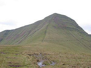
Cribyn is a mountain in the Brecon Beacons in southern Brecknockshire with an elevation of 2,608 feet.[1]
The summit lies on a ridge stretching from Talybont Reservoir in the east, to the A470 road. The ridge line to the west connects Cribyn with the peak of Pen y Fan. To the east, the ridge line descends to Bwlch ar y Fan, a mountain pass crossed by an ancient trail sometimes known as 'The Gap Road' before ascending again to the peak of Fan y Big.[1][2]
Geology
In common with other peaks of the Brecon Beacons, the upper slopes of Cribyn are formed from sandstones of the Brownstones Formation of the Old Red Sandstone laid down during the Devonian period. The lower slopes of the hill are formed from sandstones and mudstones of the underlying Senni Beds Formation. The rock strata tilt gently southwards. The heads of Cwm Sere and Cwm Cynwyn, to the northwest and east of Cribyn respectively, nurtured small glaciers during the last ice age. This glacial erosion resulted in the very steep northern and eastern faces which the hill possesses.

References
Outside links
| ("Wikimedia Commons" has material about (mountain) Cribyn) |
