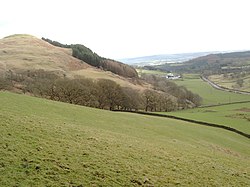
Tynron: Difference between revisions
Jump to navigation
Jump to search
Created page with "{{county|Dumfriesshire}} thumb|right|250px|Tynron Doon on left. '''Tynron''' is a villag..." |
No edit summary |
||
| Line 1: | Line 1: | ||
{{county|Dumfriesshire}} | {{county|Dumfriesshire}} | ||
[[File:Tynron Doon to the left and Clonrae Farm below - geograph.org.uk - 707242.jpg|thumb|right|250px|Tynron Doon on left.]] | [[File:Tynron Doon to the left and Clonrae Farm below - geograph.org.uk - 707242.jpg|thumb|right|250px|Tynron Doon on left.]] | ||
'''Tynron''' is a village and parish in [[Dumfriesshire]], lying in a hollow of the [[Shinnel Water]], two miles from [[Moniaive]]. | '''Tynron''' is a village and parish in [[Dumfriesshire]], lying in a hollow of the [[Shinnel Water]], two miles from [[Moniaive]]. The parish extends to the west to the border with [[Kirkcudbrightshire]]. | ||
==Tynron Doon== | ==Tynron Doon== | ||
Latest revision as of 17:56, 23 October 2015

Tynron is a village and parish in Dumfriesshire, lying in a hollow of the Shinnel Water, two miles from Moniaive. The parish extends to the west to the border with Kirkcudbrightshire.
Tynron Doon
At Tynron Doon there can be seen the ditches and ramparts of a Roman Iron Age hillfort.
For detailed information see "Tynron Glen" by John Shaw, available in Dumfries Ewart Library, a new version on tynronglenshaw.com.
| ("Wikimedia Commons" has material about Tynron) |
This Dumfriesshire article is a stub: help to improve Wikishire by building it up.
