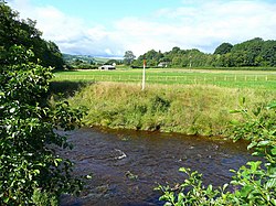
Yscir: Difference between revisions
Jump to navigation
Jump to search
Created page with "{{Infobox town | name= Yscir | welsh= | county = Brecknockshire | picture = View across the Yscir - geograph.org.uk - 917878.jpg | picture caption= | os grid ref= SO045285 |..." |
|
(No difference)
| |
Latest revision as of 13:25, 28 October 2014
| Yscir | |
| Brecknockshire | |
|---|---|

| |
| Location | |
| Grid reference: | SO045285 |
| Location: | 51°57’42"N, 3°26’59"W |
| Data | |
| Population: | 419 |
| Post town: | Brecon |
| Postcode: | LD3 |
| Dialling code: | 01874 |
| Local Government | |
| Council: | Powys |
| Parliamentary constituency: |
Brecon & Radnorshire |
Yscir or Ysgir is a parish in Brecknockshire to the north-west of Brecon. In 2011 the population of Yscir was 419.[1] It is bounded by Honddu Isaf and Brecon to the east, Glyn Tarrell to the south, Trallong to the west and Merthyr Cynog to the north.
Villages in the parish include Cradog and Aberyscir.
Aberyscir Round Cairn (51°57’52"N, 3°28’24"W) and two standing stones (Battle and Fennifach Standing Stones) are all Scheduled prehistoric Monuments dating back to the pre-Roman period.[2]
References
- ↑ Welsh Government website; 2011 Census Returns and stats; accessed 9 May 2014
- ↑ www.ancientmonuments.info website; accessed 10 May 2014.
This Brecknockshire article is a stub: help to improve Wikishire by building it up.