Difference between revisions of "Plaistow"
From Wikishire
(Created page with '{{Infobox town |name=Plaistow |county=Essex |picture=Plaistow_High_St_-_geograph.org.uk_-_61612.jpg |picture caption=Plaistow High Street |os grid ref=TQ405825 |latitude=51.5243 …') |
(No difference)
|
Revision as of 11:16, 7 July 2013
| Plaistow | |
| Essex | |
|---|---|
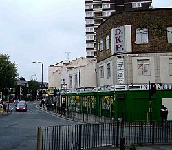
 Plaistow High Street | |
| Location | |
| Grid reference: | TQ405825 |
| Location: | 51°31’27"N, 0°1’28"E |
| Data | |
| Post town: | London |
| Postcode: | E13 |
| Dialling code: | 020 |
| Local Government | |
| Council: | Newham |
| Parliamentary constituency: |
West Ham |
Plaistow is a town in Essex within the London conurbation.
This Essex article is a stub: help to improve Wikishire by building it up.