Nidderdale
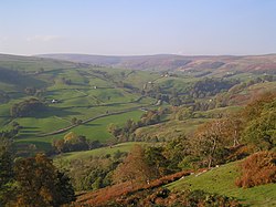
Nidderdale is one of the famous Yorkshire Dales. It carves its way through the West Riding of Yorkshire bearing the River Nidd. The dale carries the upper reaches of the Nidd, which river rises on the slopes of Great Whernside flows south through the dale and then eastward, a general course it retains even out of the dale and into the Vale of York.
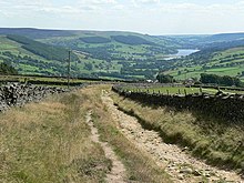
In the higher parts of the dale the Nidd has been dammed to create several reservoirs including its greatest, the Gouthwaite Reservoir.
The Nidd eventually joins the River Ouse at Nun Monkton a little north of York.
The only town in the dale is Pateley Bridge. Villages include Wath-in-Nidderdale, Ramsgill, Lofthouse, and Middlesmoor above Pateley Bridge, and Bewerley, Glasshouses, Summerbridge, Hampsthwaite, Birstwith, Darley, Kettlesing and Felliscliffe below Pateley.
The Nidderdale Way long distance footpath explores Nidderdale in a circular route 53 miles long.
Area of Outstanding Natural Beauty
Nidderdale was designated an "Area of Outstanding Natural Beauty" in 1994.[1] The Nidderdale AONB is not faithful to the dale though, its bounds drawn to hop over the hills and encompass also part of lower Wharfedale, the Washburn valley and part of lower Wensleydale, including Jervaulx Abbey and the side valleys west of the River Ure.
Transport
A Nidderdale Omnibus started operating on 1 August 1849 and ran between Pateley Bridge and Ripley Station. In 1862 the North Eastern Railway opened a branch from Nidd Valley Junction near Harrogate to Pateley Bridge. Between 1907 and 1937 the Nidd Valley Light Railway served the dale above Pateley Bridge. The Pateley Bridge branch closed in 1964.
Outside links
| ("Wikimedia Commons" has material about Nidderdale) |
- Nidderdale Inns and Pubs
- Visitors' guide to Nidderdale
- Nidderdale Area of Outstanding Natural Beauty
- Churches of Nidderdale
References
- ↑ "Local Area". Nidderdale Museum. http://www.nidderdalemuseum.com/local.asp. Retrieved 2009-10-08.

