Hail Weston
From Wikishire
| Hail Weston | |
| Huntingdonshire | |
|---|---|
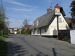
 The Royal Oak, Hail Weston | |
| Location | |
| Grid reference: | TL165621 |
| Location: | 52°14’43"N, 0°17’41"W |
| Data | |
| Postcode: | PE19 |
| Local Government | |
| Council: | Huntingdonshire |
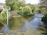
Hail Weston is a Huntingdonshire village, a few miles west of St Neots and close to the Bedfordshire border. The River Kym passes just to the north, in a flourishing meander just before it falls into the Great Ouse, and is forded by the minor road from Hail Weston to Southoe.
The village contains a park, parish church and pub.
The B645 road passes through the centre of the village between Great Staughton and Eaton Ford, and through the latter on to St Neots; this is the main road west from St Neots through southwestern Huntingdonshire to Kimbolton and beyond. A lane leads up through the ford in the Kym and over the A1 to Great Paxton.
Outside links
| ("Wikimedia Commons" has material about Hail Weston) |
