Berriedale
| Berriedale | |
| Caithness | |
|---|---|
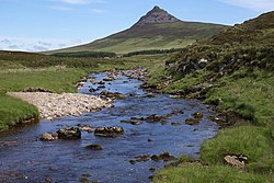
 Berriedale Water, with Maiden Paps behind | |
| Location | |
| Grid reference: | ND096223 |
| Location: | 58°10’49"N, 3°32’20"W |
| Data | |
| Postcode: | KW7 |
| Local Government | |
| Council: | Highland |
Berriedale is a small village on the east coast of Caithness. It sits where the A9 road (between Helmsdale and Lybster) makes a tight turn to cross two rivers, the Berriedale Water and Langwell Water, just before they join and enter the sea together. It is close to the boundary between Caithness and Sutherland.
The village's position shelters it mercifully from the North Sea. The village has a parish church in the Church of Scotland.
Immediately south of Berriedale where the road comes to cross the two rivers it drops down steeply to bridge a river, before rising again though a number of sharp bends in the road. This point, where the land drops to the river, is the Berriedale Braes.
The impracticality (and cost) of bridging the Berriedale Braes prevented the building of the Inverness-Wick Far North Line along the east coast of Caithness, which is why instead the railway runs inland through the Flow Country.
Outside links
| ("Wikimedia Commons" has material about Berriedale) |