Beauchene Island
| Beauchene Island | |
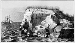
 Seal hunters in rookery on Beauchene Island, 1833 | |
|---|---|
| Location | |
| Location: | 52°53’11"S, 59°12’13"W |
| Area: | 427 acres |
| Highest point: | 230 feet |
| Data | |
| Population: | uninhabited |
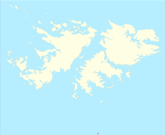
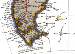
Beauchene Island is the southernmost of the Falkland Islands, lying about 34 miles south of Porpoise Point in Lafonia.[1] It was discovered in 1701 by Jacques Gouin de Beauchêne in whose honour it was named.
Geography
Beauchene is the most isolated island of the Falkland archipelago. It is uninhabited, free of introduced predators and, because it is so remote, has been protected from disturbance. It is 427 acres in area. The north of the island is covered in dense tussac with boulder beaches on the western coast and sloping up gently to about 100 feet in height. In the south of the island the land rises to around 230 feet. There are higher cliffs on the eastern coast. "The southern quarter of the island is almost bare of vegetation." [1]
There is a natural anchorage on the east side of the island, but this can only be used in fair weather. However there is no resident population and visitors are not permitted on the island without the permission of the Falkland Islands Executive Committee. A typical example was a request that was made by Falklands Conservation to make three visits in October 2010, January 2011 and March 2011 for the purpose of taking a bird census. In their application, it was noted that no people had set foot on the island since a visit by the Shallow Marine Survey Group (SMSG) in December 2009.[2]
History
Beauchene island was discovered in 1701 by Jacques Gouin de Beauchêne, after whom it is named. In later years seal trappers tried to settle the island unsuccessfully.
Some claim that Anthony de la Roché sighted Beauchene Island as early as April 1675. De la Roché had been rounding Cape Horn and was blown off course. He describes an island of high ice-covered mountains and bays in one of which la Roché anchored for a fortnight; a good description of South Georgia, not Beauchene. The claim of Beauchene, not known for mountains, let alone high ice-covered ones, is made usually by Argentines seeking a historic claim to the Falklands.
In 1834, the American McArthur landed 100 people on the island, driving the local sea lions to extinction (they have since returned).[3]
The island is currently uninhabited, but there are ruins of a group of houses built in the 1830s, on the west side of the island.
The first proper scientific expedition landed in 1951 by helicopter, staying for a month.[3]
During the Falklands War, there was an Argentine wreck on a reef just south of the islands, and British soldiers lived for around four weeks there.[3]
Flora and fauna
The island is a nature reserve. It is covered in tussac grass and is known for its colony of black-browed albatrosses. A total of thirty species of bird have been recorded on the island including rockhopper penguins. The coast is known for its caves and for its peat, which forms at around ten times the rate of anywhere else in the world. The process by which it forms so fast is not understood fully.
References
- ↑ 1.0 1.1 "Beauchêne Island". Falklands Conservation. http://www.falklandsconservation.com/wildlife/birds/IBAs/iba_beauchene.pdf. Retrieved 2010-07-20.
- ↑ Environmental Planning Officer (24 June 2010). "Request to visit Beauchene Island for Falklands Conservation five-year census.". http://www.falklands.gov.fk/assembly/documents/139-10.pdf. Retrieved 2010-07-26.
- ↑ 3.0 3.1 3.2 Wolfgang Schippke, DC3MF. "Beauchene Island / Falkland". http://www.425dxn.org/dc3mf/beauchen.html. Retrieved 2010-07-20. "For more details compare W.Schippke,'Der historische Hintergrund des Falklandkrieges von 1982', München 1982"

