Difference between revisions of "Chwarel y Fan"
From Wikishire
(Created page with '{{Infobox hill |name=Chwarel y Fan |county=Monmouthshire |range=Black Mountains |picture=Path on Chwarel y Fan - geograph.org.uk - 1753595.jpg |picture caption=Path to the summit…') |
|||
| (2 intermediate revisions by the same user not shown) | |||
| Line 7: | Line 7: | ||
|height=2,228 feet | |height=2,228 feet | ||
|os grid ref=SO258294 | |os grid ref=SO258294 | ||
| + | |latitude=51.958113 | ||
| + | |longitude=-3.081221 | ||
}} | }} | ||
| − | '''Chwarel y Fan''' is a peak in the mountainous north of [[Monmouthshire]], within the [[Black Mountains]]. Its summit the [[County top|highest point]] in [[Monmouthshire]] and the highest rise on the long ridge which extends | + | '''Chwarel y Fan''' is a peak in the mountainous north of [[Monmouthshire]] on the border with [[Brecknockshire]], within the [[Black Mountains]]. Its summit the [[County top|highest point]] in [[Monmouthshire]] and the highest rise on the long ridge which extends south-eastwards from [[Rhos Dirion]]. |
| − | The ridge continues | + | The ridge continues south-eastwards to the lesser summit of [[Bal-Mawr]] whose top is adorned by a trig point at 1,991 feet above sea level. |
| − | The summit is located on a thin ridge and is crowned by a cairn. On the other sides of the valleys: to the west is [[Pen Twyn Mawr]] and to the east is [[Black Mountain (hill)|Black Mountain]].<ref>Nuttall, John & Anne (1999). The Mountains of England & Wales - Volume 1: Wales (2nd edition ed.). Milnthorpe | + | The summit is located on a thin ridge and is crowned by a cairn. On the other sides of the valleys: to the west is [[Pen Twyn Mawr]] and to the east is [[Black Mountain (hill)|Black Mountain]].<ref>Nuttall, John & Anne (1999). The Mountains of England & Wales - Volume 1: Wales (2nd edition ed.). Milnthorpe: Cicerone. ISBN 1-85284-304-7.</ref> |
The name ''Chwarel y Fan'' means "quarry of the beacon". | The name ''Chwarel y Fan'' means "quarry of the beacon". | ||
==Outside links== | ==Outside links== | ||
| − | |||
*[http://www.geograph.org.uk/search.php?i=3454287 ‘‘Geograph.co.uk’’ photos of Waun Fach and surrounding area] | *[http://www.geograph.org.uk/search.php?i=3454287 ‘‘Geograph.co.uk’’ photos of Waun Fach and surrounding area] | ||
| Line 23: | Line 24: | ||
{{Reflist}} | {{Reflist}} | ||
| + | [[File:Summit cairn of Chwarel y Fan - geograph.org.uk - 646588.jpg|thumb|left|200px|Summit cairn]] | ||
[[Category:County tops]] | [[Category:County tops]] | ||
Latest revision as of 13:15, 6 September 2017
| Chwarel y Fan | |||
| Monmouthshire | |||
|---|---|---|---|
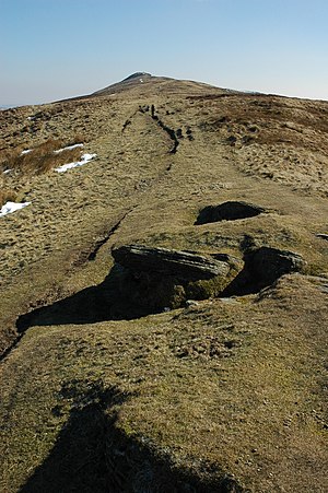
 Path to the summitt of Chwarel y Fan | |||
| Range: | Black Mountains | ||
| Summit: | 2,228 feet SO258294 51°57’29"N, 3°4’52"W | ||
Chwarel y Fan is a peak in the mountainous north of Monmouthshire on the border with Brecknockshire, within the Black Mountains. Its summit the highest point in Monmouthshire and the highest rise on the long ridge which extends south-eastwards from Rhos Dirion.
The ridge continues south-eastwards to the lesser summit of Bal-Mawr whose top is adorned by a trig point at 1,991 feet above sea level.
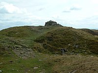
The summit is located on a thin ridge and is crowned by a cairn. On the other sides of the valleys: to the west is Pen Twyn Mawr and to the east is Black Mountain.[1]
The name Chwarel y Fan means "quarry of the beacon".
Outside links
References
- ↑ Nuttall, John & Anne (1999). The Mountains of England & Wales - Volume 1: Wales (2nd edition ed.). Milnthorpe: Cicerone. ISBN 1-85284-304-7.
