Difference between revisions of "Cùl Mòr"
| Line 1: | Line 1: | ||
{{Infobox hill | {{Infobox hill | ||
|name=Cùl Mòr | |name=Cùl Mòr | ||
| − | |county= | + | |county=Cromarty |
| − | |range= | + | |range=Coigach Hills |
|picture=CulMor.jpg | |picture=CulMor.jpg | ||
|picture caption=Cùl Mòr from the main starting point, to the east | |picture caption=Cùl Mòr from the main starting point, to the east | ||
| Line 10: | Line 10: | ||
|os grid ref=NC162119 | |os grid ref=NC162119 | ||
}} | }} | ||
| − | '''Cùl Mòr''' is a shapely, twin summited mountain in the | + | '''Cùl Mòr''' is a shapely, twin-summited mountain in the [[Coigach]] part of [[Cromartyshire]]. The mountain is almost completely separated from its southern neighbour, [[Cùl Beag]]. Despite its higher altitude, it is less well known than two of its other neighbours, [[Suilven]] and [[Stac Pollaidh]], but being higher, it commands spectacular views over these and many other neighbours. |
==Ascent== | ==Ascent== | ||
Latest revision as of 12:02, 21 September 2018
| Cùl Mòr | |||
| Cromartyshire | |||
|---|---|---|---|
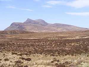
 Cùl Mòr from the main starting point, to the east | |||
| Range: | Coigach Hills | ||
| Summit: | 2,785 feet NC162119 58°3’29"N, 5°7’0"W | ||
Cùl Mòr is a shapely, twin-summited mountain in the Coigach part of Cromartyshire. The mountain is almost completely separated from its southern neighbour, Cùl Beag. Despite its higher altitude, it is less well known than two of its other neighbours, Suilven and Stac Pollaidh, but being higher, it commands spectacular views over these and many other neighbours.
Ascent
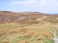
Cùl Mòr is best approached from Knockan Crag, at NC189095, where there is parking space and from where a well maintained stalker's path leads to the foot of the Meallan Diomhain ridge. The route up this ridge is marked by cairns. From the top of this ridge, the most popular route bears right, over a broad saddle, before approaching the summit from the north-east. The very last part of the ascent is quite steep and involves scrambling over boulders; otherwise this is an easy and comfortable mountain to climb. A slightly longer but possibly easier route can be climbed by way of the corrie that leads up to the col of Creag nan Calman, to the south-west of the main summit.
References
- The Corbetts and Other Scottish Hills, (SMC Guide) ISBN 0-907521-29-0
- Walk Highland
