Barrows Green, Westmorland
From Wikishire
Revision as of 21:38, 29 August 2017 by RB (Talk | contribs) (Created page with "{{Infobox town |name=Barrows Green |county=Westmorland |picture=The Punch Bowl, Barrows Green, Cumbria - geograph.org.uk - 951058.jpg |picture caption=''The Punch Bowl'' publi...")
| Barrows Green | |
| Westmorland | |
|---|---|
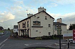
 The Punch Bowl public house, Barrows Green | |
| Location | |
| Grid reference: | SD520875 |
| Location: | 54°16’53"N, 2°44’18"W |
| Data | |
| Post town: | Kendal |
| Postcode: | LA8 |
| Dialling code: | 015395 |
| Local Government | |
| Council: | Westmorland & Furness |
| Parliamentary constituency: |
Westmorland and Lonsdale |
Barrows Green is a hamlet in Westmorland, half a mile south-east of Natland, and three miles south of Kendal town centre. It is at a crossroads on the A65 Kendal to Kirkby Lonsdale road.
Outside links
| ("Wikimedia Commons" has material about Barrows Green, Westmorland) |