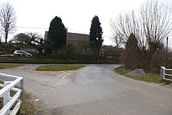
Menethorpe
From Wikishire
Revision as of 22:49, 17 June 2023 by RB (Talk | contribs) (Created page with "{{Infobox town |name=Menethorpe |county=Yorkshire |riding=East |picture=Menethorpe - geograph.org.uk - 3405725.jpg |picture caption= |os grid ref=SE768676 |latitude=54.098862...")
| Menethorpe | |
| Yorkshire East Riding | |
|---|---|

| |
| Location | |
| Grid reference: | SE768676 |
| Location: | 54°5’56"N, 0°49’35"W |
| Data | |
| Local Government | |
| Council: | North Yorkshire |
Menethorpe is a hamlet in the East Riding of Yorkshire. It is about two and a half miles from Malton.
In 1931 the parish had a population of 68.
History
The name "Menethorpe" means 'Men(n)ing's outlying farm/settlement'.[1] Menethorpe was recorded in the Domesday Book as Mennistorp.
Menethorpe was formerly a township in the parish of Westow.[2]
The remains of the abandoned mediæval village Menethorpe are visible as cropmarks and earthworks on aerial photographs.[3]
| ("Wikimedia Commons" has material about Menethorpe) |
References
- ↑ "Menethorpe Key to English Place-names". University of Nottingham. http://kepn.nottingham.ac.uk/map/place/Yorkshire%20ER/Menethorpe.
- ↑ "History of Menethorpe, in Ryedale and East Riding". A Vision of Britain through Time. https://visionofbritain.org.uk/place/13481.
- ↑ "Menethorpe". Heritage Gateway. https://www.heritagegateway.org.uk/Gateway/Results_Single.aspx?uid=MNY2357&resourceID=1009.