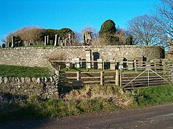
Kilchenzie
From Wikishire
Revision as of 23:13, 16 March 2022 by RB (Talk | contribs) (Created page with "{{Infobox town |name=Kilchenzie |county=Argyll |picture=Church Ruins and Beehives - geograph.org.uk - 96776.jpg |picture caption= |os grid ref=NR674249 |latitude=55.46270473 |...")
| Kilchenzie | |
| Argyllshire | |
|---|---|

| |
| Location | |
| Grid reference: | NR674249 |
| Location: | 55°27’46"N, 5°40’49"W |
| Data | |
| Local Government | |
| Council: | Argyll and Bute |
| Parliamentary constituency: |
Argyll and Bute |
Kilchenzie is a small farming community found five miles north of Campbeltown on the Kintyre peninsula of Argyllshire. It is reached from north and south by the A83 road. In 1961 it had a population of 69.[1]
References
- ↑ "Kilchenzie Details". Gazetteer for Scotland. https://www.scottish-places.info/towns/towndetails3888.html. Retrieved 15 June 2020.