Vaughan Island
From Wikishire
Revision as of 12:35, 18 October 2021 by RB (Talk | contribs) (Created page with "{{Infobox island |name=Vaughan Island |territory=SGSSI |picture= |picture caption= |map=Vaughan Island - Willis Islands.svg |latitude=54.0058 |longitude=-38.1844 |group=Willis...")
| Vaughan Island | |
|
Willis Islands
| |
|---|---|
| Location | |
| Location: | 54°0’21"N, 38°11’4"W |
| Data | |
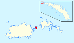
Vaughan Island is one of the Willis Islands, which lie off the western tip of South Georgia. It lies between Main Island and Trinity Island.
The island was charted from HMS Owen in 1960-61 and called 'Sugarloaf Island', descriptively from its shape. It was later named 'Vaughan Island' after Lieutenant Commander Hugh Lawrence Folliott Vaughan (b. 1926), First Lieutenant of the Owen.
References
- Gazetteer and Map of South Georgia and the South Sandwich Islands: Vaughan Island
| South Georgia and the South Sandwich Islands | |
|---|---|
| South Georgia: | Annenkov Island • Bird Island • Clerke Rocks • Cooper Island • Grass Island • Kupriyanov Islands • Pickersgill Islands • Saddle Island • Shag Rocks • South Georgia • Welcome Islands • Willis Islands • Trinity Island • Grassholm • Black Rocks • Black Rock |
| South Sandwich Islands: |
Bellingshausen • Bristol • Candlemas • Cook • Leskov • Montagu • Saunders • Thule • Vindication • Visokoi • Zavodovski |
