Conisbrough
| Conisbrough | |
| Yorkshire West Riding | |
|---|---|
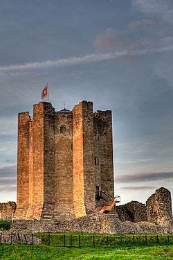
 Conisbrough Castle | |
| Location | |
| Grid reference: | SK5198 |
| Location: | 53°28’44"N, 1°13’37"W |
| Data | |
| Population: | 15,361 |
| Post town: | Doncaster |
| Postcode: | DN12 |
| Dialling code: | 01709 |
| Local Government | |
| Council: | Doncaster |
| Parliamentary constituency: |
Don Valley |
Conisbrough is a town in the West Riding of Yorkshire, roughly midway between Doncaster and Rotherham. It stands alongside the River Don.
Name
The name "Conisbrough" is derived from the Old English Cyningesburh (first recorded around 1000) meaning "King's stronghold".[1]
History
In a will of around 1003, Conisbrough was bequeathed by Wulfric Spott, founder of Burton Abbey. At this point, it appears to have been the centre of a major former royal estate, reaching Hatfield Chase. The manor became royal again under King Harold II, and by the Norman Conquest, 28 townships in this part of the West Riding belonged to the Lord of Conisbrough. William the Conqueror gave the whole lordship to William de Warenne, 1st Earl of Surrey.
The name of Conisbrough relates to a king's stronghold and this is usually presumed to have either been on the site of Conisbrough Castle, or of the parish church. At the time of the Norman Conquest the manor of Conisbrough was held by King Harold. Conisbrough Castle is contained within an artificial oval-shaped enclosure similar to one used as wapentake meeting-places at Gringley-on-the-Hill and East Markham, leading Malcolm Dolby to suppose the castle site may have once been the meeting-place of the Strafforth and Tickhill Wapentake.
Peter Langtoft, writing in the 13th century, claimed that Egbert of Wessex had been received at "Burghe Conane", which is often identified with Conisbrough.
Parish Church

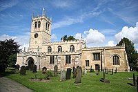
St Peter's Church may be the oldest building in Hallamshire. It dates from the 8th century. The church was enlarged in the twelfth century and seems to have been the centre of a large parish covering all or much of the eleventh century Fee of Conisbrough.
Literature
Geoffrey of Monmouth wrote about the town, claiming that it had been fortified by Ambrosius Aurelianus, king of the Britons after his victory over the Saxon forces of Hengist (Historia Regum Britanniae viii, 7), that the captive Saxon leader Hengist was hacked to pieces by Eldol outside the town walls, and was buried at "Hengist's Mound" in the town.
In Sir Walter Scott's novel, Ivanhoe, 'Coningsburgh Castle' is based on Conisbrough. Scott's Coningsburgh is a Saxon fortress, based (perhaps knowingly) on the mistaken conclusion that its unique style marked it as a non-Norman castle. The great tower is described specifically, so that it is clear that Scott has the Norman version of Conisbrough in mind.
Earth Centre
In the mid-1990s, a new tourist attraction, Earth Centre, opened on the nearby site of the former Cadeby Main Colliery; it closed in 2005 after failing to attract the expected number of visitors. A leisure centre has been built on the site of the former Denaby Main Colliery. In the 2008 drama Survivors, the Earth centre was used as the place Abby was shot and taken in.
Transport links
The town lies at the junction of the A6023 and the A630 Doncaster - Rotherham road. To the west is Denaby Main Colliery Village. Pubs in the town include the "Eagle & Child".
Archers Way in Conisbrough formerly known as Butt Hole Road. It was made famous due to its name that embarrassed local residents.[2]
The town is served by Conisbrough railway station. There are frequent services in both directions from Conisbrough railway station to destinations such as Doncaster, Mexborough, Swinton, Rotherham, Sheffield, Scunthorpe, Worksop, Retford, Gainsborough, Saxilby and Lincoln.
Outside links
| ("Wikimedia Commons" has material about Conisbrough) |
References
- ↑ 'Conisbrough Castle' by Michael Welman Thompson, Great Britain. Dept. of the Environment, H.M.S.O., 1977, ISBN 0-11-671453-0
- ↑ "Residents of 'Butt Hole Road' club together to change street's unfortunate name". Daily Mail. 29 May 2009. http://www.dailymail.co.uk/news/article-1187773/Residents-Butt-Hole-Road-club-change-streets-unfortunate-name.html. Retrieved 2009-09-06.
