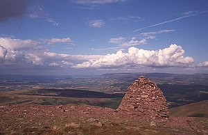
Waun Rydd
| Waun Rydd | |||
| Brecknockshire | |||
|---|---|---|---|

| |||
| Range: | Brecon Beacons | ||
| Summit: | 2,523 ft SO012215 | ||
Waun Rydd is a mountain in the Brecon Beacons National Park, in southern Brecknockshire. Its height is 2,523ft and it tops a large boggy plateau rising to the east of Pen y Fan.[1]
The hill takes the form of a plateau with sharp rims on several sides. To the northeast is Craig Pwllfa overlooking Cwm Banw whilst Craig y Fan looks east over Cwm Tarthwynni. To the south is the edge known as Cwar y Gigfran which translates into English as 'quarry of the crow'. It marks the top of a large landslipped area extending to the stream of Blaen y Glyn below.
Several ridges extend north and east from the plateau. That known as Gist Wen runs north-northeast to the subsidiary top of Bryn (1,840 ft above sea level). The short ridges of Cefn Bach and Cefn Edmwnt run northeast whilst that of Twyn Du extends eastwards towards Talybont Reservoir. A further ridge runs southeast to the subsidiary top of Allt Lwyd (2,146 ft). To the south a broad ridge runs to a col beyond which is the top of Allt Forgan (1,683 ft).
References
- ↑ Nuttall, John & Anne (1999). The Mountains of England & Wales - Volume 1: Wales (2nd edition ed.). Milnthorpe: Cicerone. ISBN 1-85284-304-7.
Outside links
- Wikishire map: 51°52’36"N, 3°21’51"W
- Waun Rydd at hill-bagging.co.uk
- www.geograph.co.uk : photos of Waun Rydd and surrounding area